

Download NCERT Solutions for Class 11 Geography Chapter 04 Map Projections
Access comprehensive textbook solutions for Chapter 04 Map Projections using the official curriculum guides for Class 11 Geography. Designed to align with the 2026-27 NCERT standards, these detailed answers help students reinforce core academic concepts.
Access NCERT Solutions and Answers
Access the complete solution PDF for Class 11 Geography below. Regular practice with these targeted textbook answers builds familiarity with standard question patterns and helps secure higher marks in final school evaluations.
NCERT Solutions for Class 11 Geography for Chapter 4 Map Projections
Exercise
1. Choose the right answer from the four alternatives given below:
(i) A map projection least suitable for the world map:
(a) Mercator
(b) Simple Cylindrical
(c) Conical
(d) All the above
Answer: (c) Conical
(ii) A map projection that is neither the equal area nor the correct shape and even the directions are also incorrect
(a) Simple Conical
(b) Polar zenithal
(c) Mercator
(d) Cylindrical
Answer: (c) Mercator
(iii) A map projection having correct direction and correct shape but area greatly exaggerated polewards is
(a) Cylindrical Equal Area
(b) Mercator
(c) Conical
(d) All the above
Answer:(b) Mercator
(iv) When the source of light is placed at the centre of the globe, the resultant projection is called
(a) Orthographic
(b) Stereographic
(c) Gnomonic
(d) All the above
Answer: (c) Gnomonic
2. Answer the following questions in about 30 words:
(i) Describe the elements of map projection.
Answer: Reduced earth, parallels of latitude, meridians of latitude and gross property are four elements of map projections.
(ii) What do you mean by global property?
Answer: The correctness of area, shape, direction and distances are the four major global properties.
(iii) Not a single map projection represents the globe truly. Why?
Answer: In preparing a map projection the distance between any given points of a region; shape of the region; size or area of the region in accuracy; and direction of any one point of the region bearing to another point are to be preserved by using one or the other methods of projections. But none of the projections can maintain all these properties simultaneously. Therefore, not a single map projection represents the globe truly.
(iv) How is the area kept equal in cylindrical equal area projection?
Answer: The cylindrical equal area projection has been derived by projecting the surface of the globe with parallel rays on a cylinder touching it at the equator. Both the parallels and meridians are projected as straight lines intersecting one another at right angles. The pole is shown with a parallel equal to the equator; hence, the shape of the area gets highly distorted at the higher latitude.
3. Differentiate between—
(i) Developable and non-developable surfaces
Answer:
|
Developable surfaces |
Non-developable surfaces |
|
Can be flattened, and on which, a network of latitude and longitude can be projected |
Cannot be flattened without shrinking, breaking or creasing |
|
A globe or spherical surface has the property of non- developable surface. |
A cylinder, a cone and a plane have the property of developable surface. |
(ii) Homolographic and orthographic projections
Answer:
|
Homolographic projection |
Orthographic projection |
|
It is an Equal Area Projection. |
It is True-Shape projection. |
|
Areas of various parts of the earth are represented correctly. |
Shapes of various areas are portrayed correctly and maintained at the cost of the correctness of area. |
(iii) Normal and oblique projections
Answer:
|
Normal projections |
Oblique projections |
|
In the normal projection, the developable surface touches the globe at the equator. |
In the oblique projection, the developable surface touches tangential to a point between the pole and the equator. |
(iv) Parallels of latitude and meridians of longitude
Answer:
|
Parallels of Latitude |
Meridians of Longitude |
|
They are demarcated as 0º to 90º North and South latitudes. |
There is no central meridian |
|
Each parallel lies wholly in its plane which is at right angle to the axis of the earth. |
Each meridian lies wholly in its plane, but all intersect at right angle along the axis of the globe. |
|
These are the circles running round the globe parallel to the equator. |
These are semi-circles drawn in north south direction from one pole to the other. |
|
They are not of equal length. |
They are of equal length. |
4. Answer the following questions in not more than 125 words:
(i) Discuss the criteria used for classifying map projection and state the major characteristics of each type of projection.
Answer: Map Projections may be classified on the following bases:
A. Drawing Techniques: On the basis of method of construction, projections are classified as follows:
i. Perspective projections are developed with the help of a source of light.ii. Non–perspective projections are developed without the help of a source of light.
iii. Mathematical projections are derived by mathematical computation, and formulae.
Developable Surface: A developable surface is a geometric shape that can be laid out into a flat surface without stretching or tearing. The three types of developable surfaces are cylinder, cone and plane, and their corresponding projections are called cylindrical, conical and planar.
Global Properties: The correctness of area, shape, direction and distances are the four major global properties to be preserved in a map. On the basis of global properties, projections are classified into equal area, orthomorphic, azimuthal and equi-distant projections.
Source of Light: On the basis of location of source of light, projections may be classified as gnomonic, stereographic and orthographic. These projections are obtained by putting the light at the centre of the globe or at the periphery of the globe or at infinity from the globe.
(ii) Which map projection is very useful for navigational purposes? Explain the properties and limitations of this projection.
Answer: Mercator’s Projection is an orthomorphic projection in which the correct shape is maintained. It has the characteristics of showing correct directions. Therefore, it is very useful for navigation purposes showing sea routes and air routes.
Properties
i. All parallels and meridians are straight lines.
ii. All parallels are equal to the length of equator.
iii. All meridians have the same length and equal spacing.
iv Scale along the equator is correct.
v. The shape of small countries increases towards pole
Limitations
i. There is greater exaggeration of scale along the high latitude For example, the size of Greenland equals to the size of USA.
ii. Poles in this projection cannot be shown as the poles lie at infi
(iii) Discuss the main properties of conical projection with one standard parallel and describe its major limitations.
Answer: A conical projection with one standard parallel is drawn by projecting the image of the graticule of a globe on a developable cone, which touches the globe along a parallel of latitude called the standard parallel.
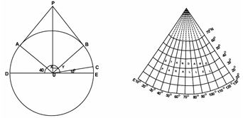
Properties
1. All the parallels are arcs of concentric circle and are equally spaced.
1. All meridians are straight lines merging at the pole and intersect the parallels at right angles.
2. The scale along all meridians is true.
3. The scale is true along the standard parallel but exaggerated away from the standard parallel.
4. Meridians become closer to each other towards the pole.
Limitations
2. It is not suitable for representing larger areas within the hemisphere as the distortion along the pole and near the equator is large
Free NCERT Textbook Explanations: Class 11 Geography Chapter 04 Map Projections
Textbook Solutions for Class 11 Geography Chapter 04 Map Projections
Review comprehensive exercise answers for Class 11 Geography Chapter 04 Map Projections. Fully updated to match current NCERT syllabus guidelines, these textbook solutions help students verify their work and maintain accurate study notes.
Mastering Theoretical and Practical Questions
Clear, methodical explanations accompany every challenging problem within the Class 11 Geography text. Engaging with these detailed answers lays a solid foundation for advanced learning and improves foundational clarity for upcoming assessments.
Effective Self-Study and Homework Assistance
These resources act as an effective roadmap for daily homework tasks and independent study. Supplement your review of Chapter 04 Map Projections with official sample papers and interactive practice tests available on our platform free of charge.
FAQs
The complete and updated NCERT Solutions Class 11 Geography Chapter 4 Map Projections is available for free on StudiesToday.com. These solutions for Class 11 Geography are as per latest NCERT curriculum.
Yes, our experts have revised the NCERT Solutions Class 11 Geography Chapter 4 Map Projections as per 2026 exam pattern. All textbook exercises have been solved and have added explanation about how the Geography concepts are applied in case-study and assertion-reasoning questions.
Toppers recommend using NCERT language because NCERT marking schemes are strictly based on textbook definitions. Our NCERT Solutions Class 11 Geography Chapter 4 Map Projections will help students to get full marks in the theory paper.
Yes, we provide bilingual support for Class 11 Geography. You can access NCERT Solutions Class 11 Geography Chapter 4 Map Projections in both English and Hindi medium.
Yes, you can download the entire NCERT Solutions Class 11 Geography Chapter 4 Map Projections in printable PDF format for offline study on any device.