
Download the latest CBSE Class 11 Geography Structure And Physiography Notes in PDF format. These Class 11 Geography revision notes are carefully designed by expert teachers to align with the 2026-27 syllabus. These notes are great daily learning and last minute exam preparation and they simplify complex topics and highlight important definitions for Class 11 students.
Revision Notes for Class 11 Geography India Physical Environment Chapter 2 Structure and Physiography
To secure a higher rank, students should use these Class 11 Geography India Physical Environment Chapter 2 Structure and Physiography notes for quick learning of important concepts. These exam-oriented summaries focus on difficult topics and high-weightage sections helpful in school tests and final examinations.
India Physical Environment Chapter 2 Structure and Physiography Revision Notes for Class 11 Geography
PHYSIOGRAPHY - INDIA
PHYSIOGRAPHY
• Structure and Relief; physiographic divisions
• Drainage systems: concept of water sheds — the Himalayan and the Peninsular
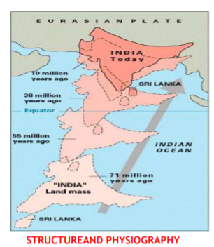
Can you map different phases in the movement of the Indian plate?
This northward movement of the Indian plate is continuing and it has significant consequences on the physical environment of the Indian subcontinent.
Can you name some important consequences of the northward movement of the Indian plate?
1. FORMATION OF HIMALAYAS
2. FORMATION OF INDO GANGETIC PLAIN
3. ARABIAN SEA FORMATION 4. EMERGENCE OF DECCAN PLATEAU
It is primarily through the interplay of these endogenic and exogenic forces and lateral movements of the plates that the present geological structure and geomorphologic processes active in the Indian subcontinent came into existence.
Based on the variations in its geological structure and formations, India can be divided into three geological divisions.
(i) The Peninsular Block
(ii) The Himalayas and other Peninuslar Mountains
(iii)Indo-Ganga-Brahmaputra Plain.
THE PENINSULAR BLOCK
Boundaries of the PENINSULAR BLOCK
1. The northern boundary of the Peninsular Block may be taken as an irregular line Movement of Indian plate running from Kachch along the western flank of the Aravali Range near Delhi and then roughly parallel to the Yamuna and the Ganga as far as the Rajmahal Hills and the Ganga delta. Apart from these,
2. The Karbi Anglong and the Meghalaya Plateau in the northeast and Rajasthan in the west are also extensions of this block. 3.The northeastern parts are separated by the Malda fault in West Bengal from the Chotanagpur plateau.
4.T he Peninsula is formed essentially by a great complex of very ancient gneisses and granites,
5. Since the Cambrian period, the Peninsula has been standing like a rigid block with the exception of some of its western coast which is submerged beneath the sea and some other parts changed due to tectonic activity without affecting the original basement.
6. As a part of the Indo-Australian Plate, it has been subjected to various vertical movements and block faulting. The rift valleys of the Narmada, the Tapi and the Mahanadi and the Satpura block mountains are some examples of it. The Peninsula mostly consists of relict and residual mountains like the Aravali hills, the Nallamala hills, the Javadi hills, the Veliconda hills, the Palkonda range and the Mahendragiri hills, etc.
THE HIMALAYAS AND OTHER PENINSULAR MOUNTAINS
1. The Himalayas along with other Peninsular mountains are young, weak and flexible in their geological structure unlike the rigid and stable Peninsular Block.
2. Consequently, they are still subjected to the interplay of exegetic and endogenic forces, resulting in the development of faults, folds and thrust plains.
3. These mountains are tectonic in origin, dissected by fast-flowing rivers which are in their youthful stage.
4. Various landforms like gorges, V-shaped valleys, rapids, waterfalls, etc. are indicative of this stage.
INDO-GANGA-BRAHMAPUTRA PLAIN
The third geological division of India comprises the plains formed by the river Indus, the Ganga and the Brahmaputra. It was a geo-synclinal depression which attained its maximum development during the third phase of the Himalayan mountain formation approximately about 64 million years ago. Since then, it has been gradually filled by the sediments brought by the Himalayan and Peninsular rivers. Average depth of alluvial deposits in these plains ranges from 1,000-2,000 m.
PHYSIOGRAPHY
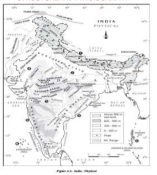
Physiography‘ of an area is the outcome of structure, process and the stage of development. India can be divided into the following physiographic divisions:
(1) The Northern and North-eastern Mountains
(2) The Northern Plain
(3) The Peninsular Plateau
(4) The Indian Desert
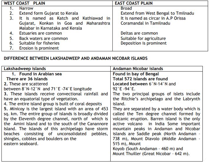
(5) The Coastal Plains
(6) The Islands.
The North and Northeastern Mountains
1. The North and Northeastern Mountains consist of the Himalayas and the Northeastern hills.
2. The Himalayas consist of a series of parallel mountain ranges.
Some of the important ranges are the Greater Himalayan range, which includes the Great Himalayas and the Trans-Himalayan range, the Middle Himalayas and the Shiwalik.
3. The general orientation of these ranges is from northwest to the southeast direction in the northwestern part of India. Himalayas in the Darjeeling and Sikkim regions lie in an east west direction, while in Arunachal Pradesh they are from southwest to the northwest direction. In Nagaland, Manipur and Mizoram, they are in the north south direction.
4. The approximate length of the Great 2500 km ,width is 160 to 400 km
6. Himalayas are not only the physical barrier, they are also a climatic, drainage and cultural divide. THE HIMALAYAS CAN BE DIVIDED INTO THE FOLLOWING SUB-DIVISIONS:
(i) Kashmir or Northwestern Himalayas
(ii) Himachal and Uttaranchal Himalayas
(iii) Darjiling and Sikkim Himalayas
(iv) Arunachal Himalayas
(v) Eastern Hills and Mountains.
Kashmir or Northwestern Himalayas
1. It comprise a series of ranges such as the KARAKORAM, LADAKH, ZASKAR AND PIR PANJAL.
2 .It is a cold desert, which lies between the Greater Himalayas and the Karakoram ranges.
3. The world famous valley of Kashmir and the famous Dal Lake are found.
4. Important glaciers Baltoro and Siachen are also found in this region.
5. The Kashmir Himalayas are also famous for Karewa formations, which are useful for the cultivation of Zafran, a local variety of saffron.
6. Some of the important passes of the region are ZojiLa on the Great Himalayas, Banihal on the Pir Panjal,Photu La on the Zaskar and Khardung La on the Ladakh range.
7. Some of the important fresh lakes such as Dal and Wular and salt water lakessuch as Pangong Tso and Tso Moriri are also in this region.
8. This region is drained by the river Indus, and its tributaries such as the Jhelum and the Chenab.
9. The landscape of Himalayas is a major source of attraction for adventure tourists. some famous places of pilgrimage such as Vaishno Devi, Amarnath Cave, Charar -e-Sharif.
10. The southernmost part of this region consists of longitudinal valleys known as ‗duns‘. Jammu dun and Pathankot dun are important examples.
The Himachal and Uttarakhand Himalayas
1. The northernmost part of the Himachal Himalayas is an extension of the Ladakh cold desert, in which all the three ranges of Himalayas are prominent. These are the Great Himalayan range, the Lesser Himalayas (which is locally known as Dhaoladhar in Himachal Pradesh and Nagtibha in Uttarakhand)and the Shiwalik range from the North to the South 0
2. In this section of Lesser Himalayas, the altitude between 1,000-2,000m
3. The important hill stations such as Dharamshala, Mussoorie, Shimla, Kaosani and the cantonment towns and health resorts such as Shimla, Mussoorie, Kasauli, Almora, Lansdowne and Ranikhet, etc.
4. The two distinguishing features of this region from the point of view of physiography are the ‗Shiwalik‘ and ‗Dun formations‘. Some important duns located in this region are the the places of pilgrimage such as the Gangotri, Yamunotri, Kedarnath, Badrinathand Hemkund Sahib are also situated in this part.
5. The region is also known to have five famous Prayags (river confluences)
The Darjeeling and Sikkim Himalayas
1. They are flanked by Nepal Himalayas in the west and Bhutan Himalayas in the east.
2. It is relatively small but is a most significant part of the Himalayas.
3. Known for its fast-flowing rivers such as Tista,
4. It is a region of high mountain peaks like Kanchenjunga (Kanchengiri), and deep valleys.
5. The higher reaches of this region are inhabited by Lepcha tribes while the southern part, particularly
6. Tea plantation is done
7. Absence of siwaliks
8. Duar formations are important .
The Arunachal Himalayas
1. These extend from the east of the Bhutan Himalayas up to the Diphu pass in the east.
2. The general direction of the mountain range is from southwest to northeast.
3. Some of the important mountain peaks of the region are Kangtu and Namcha Barwa.
4. These ranges are dissected by fast-flowing rivers from the north to the south, forming deep gorges.
5. The important river is Brahmaputra flows through a deep gorge after crossing Namcha Barwa. Some of the important rivers are the Kameng, the Subansiri, the Dihang, the Dibang and the Lohit.
6. These are perennial with the high rate off all, thus, having the highest hydro-electric power potential in the country.
7. The important tribes are the Monpa, Daffla, Abor, Mishmi, Nishi and the Nagas. Most of these communities practise Jhumming. It is also known as shifting or slash and burn cultivation.
The Eastern Hills and Mountains
1. These are part of the Himalayan mountain system having their general alignment from the north to the south direction.
They are known by different local names. In the north, they are known as Patkai Bum, Naga hills, the Manipur hills and in the south as Mizo or Lushai hills.
(i) These are low hills, inhabited by numerous tribal groups practicing Jhum cultivation.
(ii) Most of these ranges are separated from each other by numerous small rivers.
(iii) The Barak is an important river in Manipur and Mizoram.
(iv) The physiography of Manipur is unique by the presence of a large lake known as ‗Loktak‘ lake at the centre, surrounded by mountains from all sides.
(v) Mizoram which is also known as the ‗Molassis basin‘ which is made up of soft unconsolidated
The Northern Plains
1. The northern plains are formed by the alluvial deposits brought by the rivers – the Indus, the Ganga and the Brahmaputra.
2. These plains extend approximately 3,200 km from the east to the west.
3. The average width of these plains varies between 150-300 km.
4. The maximum depth of alluvium deposits varies between 1,000-2,000 m. From the north to the south
5. these can be divided into three major zones: the Bhabar, the Tarai and the alluvial plains.
6. The alluvial plains can be further divided into the Khadar and theBhangar.
7. Bhabar is a narrow belt ranging between 8-10 km parallel to the Shiwalik foothills at the break-up of the slope.
8.The streams and rivers coming from the mountains deposit heavy materials of rocks and boulders, and at times, disappear in this zone.
9. South of the Bhabar is the Tarai belt, with an approximate width of 10-20 km where most of the streams and rivers re-emerge without having any properly demarcated channel,
10. Marshy and swampy conditions known as the Tarai.
11. This has a luxurious growth of natural vegetation and houses a varied wild life.
12. The south of Tarai is a belt consisting of old and new alluvial deposits known as the Bhangar and Khadar respectively.
The Peninsular Plateau
1. Irregular triangle in shape
2. Rising from the height of 150 m above the river plains up to an elevation of 600-900 m
3. Delhi ridge in the northwest, (extension of Aravalis), the Rajmahal hills in the east, Gir range in the west and the Cardamom hills in the south constitute the outer extent of the Peninsular plateau. northeast, Shillong and Karbi-Anglong plateau.
4. The Peninsular India is made up of a series of patland plateaus such as the Hazaribagh plateau, the Palamu plateau, the Ranchi plateau, the Malwa plateau, the Coimbatore plateau and the Karnataka plateau, etc.
5. This is one of the oldest and the most stable landmass of India.
6. The general elevation of the plateau is from the west to the east, .
7. Narmada, tapti ,Mahanadi, Godavari, Krishna, and cauvery are some of the important rivers
8. Some of the important physiographic features of this region are tors, block mountains, rift valleys, spurs, bare rocky structures, series of hummocky hills and wall-like quartzite dykes offering natural sites for water storage.
9. Thewestern and northwestern part of the plateau has an emphatic presence of black soil.
10. The northwestern part of the plateau has a complex relief of ravines and gorges. The ravines of Chambal, Bhind and Morena are some of the well-known examples. On the basis of the prominent relief features, the Peninsular plateau can be divided into three broad groups:
(i) The Deccan Plateau
(ii) The Central Highlands
(iii) The Northeastern Plateau.
The Deccan Plateau
1. This is bordered by the Western Ghats in the west, Eastern Ghats in the east and the Satpura, Maikal range and Mahadeo hills in the north.
2. Western Ghats are locally known by different names such as Sahyadri in Maharashtra, Nilgiri hills in Karnataka and Tamil Nadu and Anaimalai hills and Cardamom hills in Kerala.
3. Western Ghats are comparatively higher in elevation and more continuous than the Eastern Ghats. Their average elevation is about 1,500 m with the height increasing from north to south.
4. Anaimudi‘ (2,695 m), the highest peak of Peninsular plateau is located on the Anaimalai hills of the Western Ghats followed by Dodabetta(2,637 m) on the Nilgiri hills.
5. Most of the Peninsular rivers have their origin in the Western Ghats. Eastern Ghats comprising the discontinuous and low hills are highly eroded by the rivers such as the Mahanadi, the Godavari, the Krishna, the Kaveri, etc.
6. Some of the important ranges include the Javadi hills, the Palkonda range, the Nallamala hills, the Mahendragiri hills, etc.
7. The Eastern and the Western Ghats meet each other at the Nilgiri hills.
The Central Highlands
1.They are bounded to the west by the Aravali range.
2. The Satpura range is formed by a series of scarped plateaus on the south, generally at an elevation varying between 600-900 m above the mean sea level.
3. This forms the northernmost boundary of the Deccan plateau.
4. It is a classic example of the relict mountains which are highly denuded and form discontinuous ranges.
5. This region has undergone metamorphic processes in its geological history, which can be corroborated by the presence of metamorphic rocks such as marble, slate, gneiss, etc.
6. The general elevation of the Central Highlands ranges between 700-1,000 m
7. Banas is the only significant tributary of the river Chambal that originates from the Aravalli in the west.
8. An eastern extension of the Central Highland is formed by the Rajmahal hills, to the south of which lies a large reserve of mineral resources in the Chotanagpur plateau.
The Northeastern Plateau
1. It is an extension of the main Peninsular plateau.
2. It is believed that due to the force exerted by the northeastward movement of the Indian plate at the time of the Himalayan origin, a huge fault was created between the Rajmahal hills and the Meghalaya plateau. Later, this depression got filled up by the deposition activity of the numerous rivers.
3. The Meghalaya and Karbi Anglong plateau stand detached from the main Peninsular Block.
The Meghalaya plateau is further sub-divided into three:
(i) The Garo Hills; (ii) The Khasi Hills; (iii) The Jaintia Hills, named after the tribal groups inhabiting this region.
4. An extension of this is also seen in the Karbi Anglong hills of Assam.
5 .Rich in mineral resources like coal, iron ore, sillimanite, limestone and uranium.
6. The Meghalaya plateau has a highly eroded surface.
7. Cherrapunji displays a bare rocky surface devoid of any permanent vegetation cover.
The Indian Desert
1. Located at the north west of India
2. It is a land of undulating topography dotted with longitudinal dunes and barchans.
3. This region receives low rainfall below 150 mm per year; hence,
4 It has arid climate with low vegetation cover.
5. It is because of these characteristic features that this is also known as Marusthali.
7 It is believed that during the Mesozoic era, this region was under the sea.
8. This can be corroborated by the evidence available at wood fossils park at Aakal and marine deposits around Brahmsar, near Jaisalmer (The approximate age of the wood fossils is estimated to be 180 million years).
CBSE Class 11 Geography India Physical Environment Chapter 2 Structure and Physiography Notes
Students can use these Revision Notes for India Physical Environment Chapter 2 Structure and Physiography to quickly understand all the main concepts. This study material has been prepared as per the latest CBSE syllabus for Class 11. Our teachers always suggest that Class 11 students read these notes regularly as they are focused on the most important topics that usually appear in school tests and final exams.
NCERT Based India Physical Environment Chapter 2 Structure and Physiography Summary
Our expert team has used the official NCERT book for Class 11 Geography to design these notes. These are the notes that definitely you for your current academic year. After reading the chapter summary, you should also refer to our NCERT solutions for Class 11. Always compare your understanding with our teacher prepared answers as they will help you build a very strong base in Geography.
India Physical Environment Chapter 2 Structure and Physiography Complete Revision and Practice
To prepare very well for y our exams, students should also solve the MCQ questions and practice worksheets provided on this page. These extra solved questions will help you to check if you have understood all the concepts of India Physical Environment Chapter 2 Structure and Physiography. All study material on studiestoday.com is free and updated according to the latest Geography exam patterns. Using these revision notes daily will help you feel more confident and get better marks in your exams.
FAQs
You can download the teacher prepared revision notes for CBSE Class 11 Geography Structure And Physiography Notes from StudiesToday.com. These notes are designed as per 2026-27 academic session to help Class 11 students get the best study material for Geography.
Yes, our CBSE Class 11 Geography Structure And Physiography Notes include 50% competency-based questions with focus on core logic, keyword definitions, and the practical application of Geography principles which is important for getting more marks in 2026 CBSE exams.
Yes, our CBSE Class 11 Geography Structure And Physiography Notes provide a detailed, topic wise breakdown of the chapter. Fundamental definitions, complex numerical formulas and all topics of CBSE syllabus in Class 11 is covered.
These notes for Geography are organized into bullet points and easy-to-read charts. By using CBSE Class 11 Geography Structure And Physiography Notes, Class 11 students fast revise formulas, key definitions before the exams.
No, all study resources on StudiesToday, including CBSE Class 11 Geography Structure And Physiography Notes, are available for immediate free download. Class 11 Geography study material is available in PDF and can be downloaded on mobile.