
Download the latest CBSE Class 11 Geography Natural Hazards And Disasters Notes in PDF format. These Class 11 Geography revision notes are carefully designed by expert teachers to align with the 2026-27 syllabus. These notes are great daily learning and last minute exam preparation and they simplify complex topics and highlight important definitions for Class 11 students.
Revision Notes for Class 11 Geography India Physical Environment Chapter 6 Natural Hazards and Disasters
To secure a higher rank, students should use these Class 11 Geography India Physical Environment Chapter 6 Natural Hazards and Disasters notes for quick learning of important concepts. These exam-oriented summaries focus on difficult topics and high-weightage sections helpful in school tests and final examinations.
India Physical Environment Chapter 6 Natural Hazards and Disasters Revision Notes for Class 11 Geography
NATURAL HAZARDS AND DISASTERS:
CAUSES, CONSEQUENCES AND MANAGEMENT
This unit deals with• Floods and droughts• Earthquakes and tsunami• Cyclones • Landslides
NATURAL HAZARDS AND DISASTERS
What is a Disaster?
―Disaster is an undesirable occurrence resulting from forces that are largely outside human control, strikes quickly with little or no warning, which causes or threatens serious disruption of life and property including death and injury to a large number of people, and requires therefore, mobilisation of efforts in excess of that which are normally provided by statutory emergency services‖.
disasters as a consequence of natural forces; and human beings were treated as innocent and helpless victims in front of the mighty forces of nature.
TYPES OF DISASTERS
NATURAL:
1. EARTH QUAKES. 2. VOLCANIC ERUPTIONS 3. LANDSLIDES 4. FOREST FIRES
5. FLOODS 6.TSUNAMIES 7. DISEASES
MAN MADE DISASTERS
1. NUCLEAR EXPLOSIONS
2. EARTH QUAKES CAUSED BY DAM CONSTRUCTION
3.HIV AIDS
4 MINING
5. ENVIRONMENTAL POLLUTION
6. LEAKAGE OF NUCLEAR MATERIAL
Establishment of National Institute of Disaster Management, India, Earth Summit at Rio de Janeiro, Brazil, 1993 and the World Conference on Disaster Management in May 1994 at Yokohama, Japan, etc. are some of the concrete steps towards this direction initiated at different levels.
Natural Hazards are elements of circumstances in the Natural environment that have the potential to cause harm to people or property or both.
Natural disasters are relatively sudden and cause large scale, widespread death, loss of property and disturbance to social systems and life over which people have a little or no control.
Thus, any event can be classed as disaster when the magnitude of destruction and damage caused by it is very high. Generally, disasters are generalized experiences of people the world over, and no two disasters are similar and comparable to each other. Every disaster is unique in terms of the local socio-environmental factors that control it, the social response it generates, and the way each social group negotiates with it.
However, the opinion mentioned above is indicative of three important things.
1. Firstly, the magnitude, intensity, frequency and damages caused by natural disasters have increased over the years.
2.Secondly, there is a growing concern among people the world over to deal with the menace created by these so that the loss of human life and property can be minimized.
3.finally, significant changes have taken place in the pattern of natural disasters over the years.
There has also been a change in the perception of natural disasters and hazards. Areas prone to natural hazards, were more vulnerable to disasters. Hence, this issue was raised at the U.N. General Assembly in 1989 and it was finally formalized at
the World Conference on Disaster Management in May 1994 at Yokohama, Japan. This was subsequently called the Yokohama Strategy and Plan of Action for a Safer World.
Table 7.1 : Some Natural Disasters Since 1948
Year Location Type
1948 The Soviet Union (now Russia) Earthquakes
1949 China Floods
1954 China Floods
1965 East Pakistan (now Bangladesh) Tropical Cyclones
1968 Iran Earthquakes
1970 Peru Earthquakes
1970 East Pakistan (now Bangladesh) Tropical Cyclones
1971 India Tropical Cyclones
1976 China Earthquakes
1990 Iran Earthquakes
2004 Indonesia, Sri Lanka, India, etc. Tsunamis
2005 Pakistan, India Earthquakes
2011 Japan Tsunami
Source : United Nations Environmental Programme (UNEP), 1991
*News Report from National Institute for Disaster Management, Government of India, New Delhi
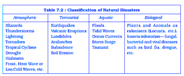
Table 7.2 : Classification of Natural Disasters
Yokohama Strategy and International Decade for Natural Disaster Reduction (IDNDR) Yokohama Strategy and Plan of Action for a Safer World
All the member states of the United Nations and other states met at the World Conference on Natural Disaster Reduction in the city of Yokohama from May 23rd- 27th 1994. It acknowledged that the impact of natural disasters in terms of human and economic losses has risen in recent years, and society, in general, has become vulnerable to natural disasters. It also accepted that these disasters affected the poor and disadvantageous groups the worst, particularly in the developing countries, which are ill-equipped to cope with them. Hence, the conference adopted the Yokohama strategy as a guide to rest of the decade and beyond, to mitigate the losses due to these disasters.
The resolution of the World Conference on Natural Disasters Reduction is as mentioned below:
(i) It will note that each country has the sovereign responsibility to protect its citizens from natural disasters;
(ii) It will give priority attention to the developing countries, particularly the least developed, landlocked countries and small-island developing states;
(iii) It will develop and strengthen national capacities and capabilities and, where appropriate, national legislation for natural and other disaster prevention, mitigation and preparedness, including the mobilisation of non-governmental organisations and participation of local communities;
(iv) It will promote and strengthen sub-regional, regional and international cooperation in activities to prevent, reduce and mitigate natural and other disasters, with particular emphasis on:
(a) human and institutional capacity-building and strengthening;
(b) technology sharing: the collection, the dissemination and utilisation of information; and
(c) mobilisation of resources. It also declared the decade 1990-2000 as the International Decade for Natural Disaster Reduction (IDNDR).
NATURAL DISASTERS AND HAZARDS IN INDIA
REASONS FOR MORE DISASTERS IN INDIA
1.India is vast and diverse in terms of its physical and socio-cultural attributes.
2.It is largely due to its vast geographical area,
3.Environmental diversities and cultural pluralities that scholars often described it using two meaningful adjectives like the ‗Indian-subcontinent‘ and the ‗land of unity in diversity‘.
4.Its vastness in terms of natural attributes combined with its prolonged colonial past, continuing various forms of social discriminations and also equally large population have enhanced its vulnerability to natural disasters.
Earthquakes
Earthquakes are by far the most unpredictable and highly destructive of all the natural disasters.
CAUSES OF EARTHQUAKES
1. NATURAL
A. tectonic B. volcanic C land slides
2.MAN MADE
1. mining 2. Nuclear explosion 3. Dam induced
Earthquakes that are of tectonic origin have proved to be the most devastating and their area of influence is also quite large.
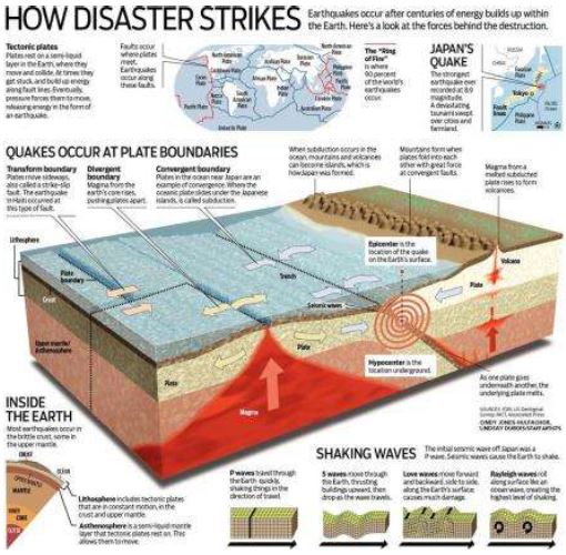
These earthquakes result from a series of earth movements brought about by a sudden release of energy during the tectonic activities in the earth‘s crust. As compared to these, the earthquakes associated with volcanic eruption, rock fall, landslides, subsidence, particularly in the mining areas, impounding of dams and reservoirs, etc. have limited area of influence and the scale of damage. National Geophysical Laboratory, Geological Survey of India, Department of Meteorology, Government of India, along with the recently formed National Institute of Disaster Management, have made an intensive analysis of more than 1,200 earthquakes that have occurred in India in different years in the past, and based on these, they divided
India into the following five earthquake zones:
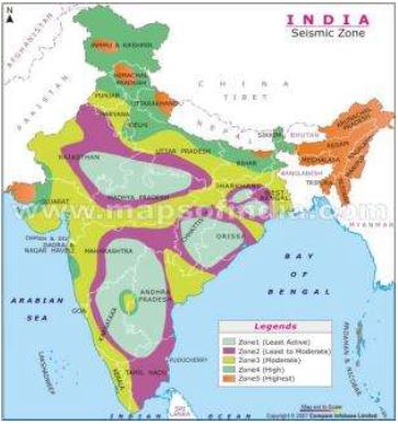
(i) Very high damage risk zone
(ii) High damage risk zone
(iii) Moderate damage risk zone
(iv) Very low damage risk zone.
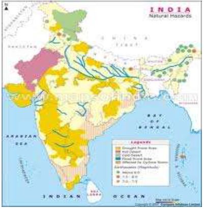
1.Out of these, the first two zones had experienced some of the most devastating earthquakes in India. As shown in the Figure areas vulnerable to these earthquakes are the North-east states, areas to the north of Darbhanga and Araria along the Indo-Nepal border in Bihar, Uttarakhand, Western Himachal Pradesh (around Dharamshala) and Kashmir Valley in the Himalayan region and the Kuchchh (Gujarat).
2. These are included in the Very High Damage Risk Zone.
Similarly, the remaining parts of Jammu and Kashmir, Himachal Pradesh, Northern parts of Punjab, Eastern parts of Haryana, Delhi, Western Uttar Pradesh, and Northern Bihar fall under the High Damage Risk Zone.
3. Remaining parts of the country fall under moderate to very Low Damage Risk Zone.
Most of the areas that can be considered safe are from the stable landmass covered under the Deccan plateau.
Socio-Environmental Consequences of Earthquakes
The idea of an earthquake is often associated with fear and horror due to the scale, magnitude and suddenness at which it spreads disasters on the surface of the earth without discrimination. It becomes a calamity when it strikes the areas of high density of population. It not only damages and destroys the settlements, infrastructure, transport and communication network, industries and other developmental activities but also robs the population of their material and socio-cultural gains that they have preserved over generations. It renders them homeless, which puts an extra-pressure and stress, particularly on the weak economy of the developing countries.
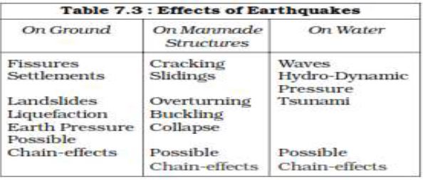
Effects of Earthquakes
Earthquakes have all encompassing disastrous effects on the area of their occurrence. Some of the important ones are listed in Table 7.3.
Table 7.3 : Effects of Earthquakes
Earthquake Hazard Mitigation
Methods to decrease the effects of Earthquake
(i) Establishing earthquake monitoring centres (seismological centres) for regular monitoring and fast dissemination of information among the people in the vulnerable areas. Use of Geographical Positioning System (GPS) can be of great help in monitoring the movement of tectonic plates.
(ii) Preparing a vulnerability map of the country and dissemination of vulnerability risk information among the people and educating them about the ways and means minimizing the adverse impacts of disasters.
(iii) Modifying the house types and building designs in the vulnerable areas and discouraging construction of high-rise buildings, large industrial establishments and big urban centres in such areas.
(iv) Finally, making it mandatory to adopt earthquake-resistant designs and use light materials in major construction activities in the vulnerable areas.
Earthquakes and volcanic eruptions that cause the sea-floor to move abruptly resulting in sudden displacement of ocean water in the form of high vertical waves are called tsunamis
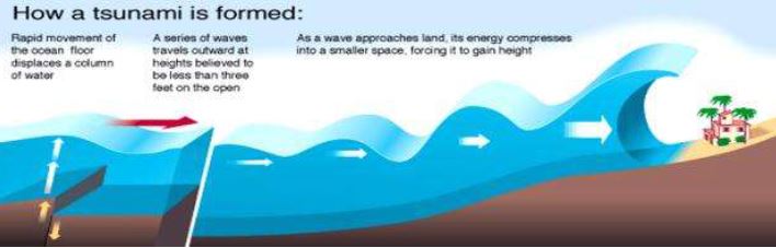
(harbour waves) or seismic sea waves. Normally, the seismic waves cause only one instantaneous vertical wave; but, after the initial disturbance, a series of after waves are created in the water that oscillate between high crest and low trough in order to restore the water level.
The speed of wave in the ocean depends upon the depth of water. It is more in the shallow water than in the ocean deep.
As a result of this, the impact of tsunami is less over the ocean and more near the coast where they cause large-scale devastations.
when a tsunami enters shallow water, its wave-length gets reduced and the period remains unchanged, which increases the wave height. Sometimes, this height can be up to 15m or more, which causes large-scale destructions along the shores. Thus, these are also called Shallow Water Waves.
Tsunamis are frequently observed along the Pacific ring of fire, particularly along the coast of Alaska, Japan, Philippines, and other islands of Southeast Asia, Indonesia, Malaysia, Myanmar, Sri Lanka, and India etc.
The effect of tsunami is more along the coast because the density of population is high.
MITIGATION
It is beyond the capacity of individual state or government to mitigate the damage. Hence, combined efforts at the international levels are the possible ways of dealing with these disasters as has been in the case of the tsunami that occurred on 26th December 2004 in which more than 300,000 people lost their lives. India has volunteered to join the International Tsunami Warning System after the December 2004 tsunami disaster.
Tropical Cyclone
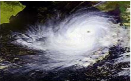
Tropical cyclones are intense lowpressure are as confined to the area lying between 30° N and 30° S latitudes, in the atmosphere around which high velocity winds blow.
Horizontally, it extends up to 500-
1,000 km and vertically from surface to 12-14 km. A tropical cyclone or hurricane is like a heat engine that is energized by the release of latent heat on account of the condensation of moisture that the wind initial conditions for the emergence of a tropical cyclone are:
(i) Large and continuous supply of warm and moist air that can release enormous latent heat.
(ii) Strong Coriolis force that can prevent filling of low pressure at the centre (absence of Coriolis force near the equator prohibits the formation of tropical cyclone between 0° -5°latitude).
(iii) Unstable condition through the troposphere that creates local disturbances around which a cyclone develops.
(iv) Finally, absence of strong vertical wind wedge, which disturbs the vertical transport of latent heat.
Structure of Tropical Cyclone
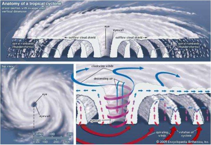
Tropical cyclones are characterised by large pressure gradients. The centre of the cyclone is mostly a warm and low-pressure, cloudless core known as eye of the storm. Generally, the isobars are closely placed to each other showing high-pressure gradients. Normally, it varies between 14- 17mb/100 km, but sometimes it can be as high as 60mb/100km. Expansion of the wind belt is about 10-150 km from the centre.
Spatio-temporal Distribution of Tropical Cyclone in India
The tropical cyclones in India also originate in Arabian sea and Bay of Bengal Though most of the cyclones originate between 10°-15° north latitudes during the monsoon season, Yet in case of the Bay of Bengal, cyclones mostly develop during the months of October and November. Here, they originate between 16°-2° N latitudes and to the west of 92° E. By July the place of origin of these storms shifts to around 18° N latitude and west of 90°E near the Sunderban Delta.
Consequences of Tropical Cyclones
It was mentioned that the energy to the tropical cyclone comes from the latent heat released by the warm moist air. Hence, with the increase in distance from the sea, the force of the cyclone decreases. In India, the force of the cyclone decreases with increase in distance from the Bay of Bengal and the Arabian Sea. So, the coastal areas are often struck by severe cyclonic storms with an average velocity of 180 km/h. Often, this results in abnormal rise in the sea level known as Storm Surge.
A surge is generated due to interaction of air, sea and land. The cyclone provides the driving force in the form of very high horizontal pressure-gradient and very strong surface winds. The sea water flows across the coast along with strong winds and heavy downpour. This results in inundation of human settlements, agricultural fields, damaging crops and destruction of structures created by human beings.
Floods
Causes of Floods
1. Sudden and Heavy rainfall
2. Loose soil
3. Deforestation
4. Unconsolidated material
5. Encroachment of rivers by the settlements
Areas of India frequently affected by floods
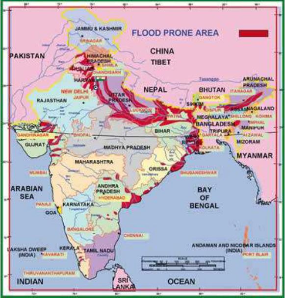
Rashtriya Barh Ayog (National Flood Commission) identified 40 million hectares of land as floodprone in India.
Consequence and Control of Floods
1.Frequent inundation of agricultural land and human settlement, particularly in Assam, West Bengal, Bihar and Eastern Uttar Pradesh (flooding rivers), coastal areas of Orissa, Andhra Pradesh, Tamil Nadu and Gujarat (cyclone) and Punjab, Rajasthan, Northern Gujarat and Haryana (flash floods) have
2.Serious consequences on the national economy and society.
3.Floods do not only destroy valuable crops every year but these also 4. damage physical infrastructure such as roads, rails, bridges and human settlements.
5. Millions of people are rendered homeless and are also washed down along with their cattle in the floods.
6.Spread of diseases like cholera, gastro-enteritis, hepatitis and other water-borne diseases spread in the flood-affected areas.
7. Every year, floods deposit fertile silt over agricultural fields which is good for the crops.
8.Majuli (Assam), the largest riverine island in the world, is the best example of good paddy crops after the annual floods in Brahmaputra.
METHODS TO CONTROL THE FLOODS
1. Construction of flood protection embankments in the flood-prone areas,
2. Construction of dams,
3. Afforestation
4. Discouraging major construction activities in the upper reaches of most of the flood-creating rivers
5. Removal of human encroachment from the river channels 6. depopulating the flood plains can be the other steps.
7. Establishment of Cyclone centres may provide relief in coastal areas which are hit by a storm surge.
Droughts
The term ‗drought‘ is applied to an extended period when there is a shortage of water availability due to inadequate precipitation, excessive rate of evaporation and over-utilization of water from the reservoirs and other storages, including the ground water.
Drought is a complex phenomenon as it involves elements of meteorology like
1. Precipitation
2. Evaporation,
3. Evapotranspiration,
4. Ground water,
5. Soil moisture,
6. Storage
7. Surface run-off,
8. Agricultural practices, particularly the types of crops grown, socio-economic practices and ecological conditions.
Types of Droughts
Meteorological Drought : It is a situation when there is a prolonged period of inadequate rainfall marked with mal-distribution of the same over time and space.
Agricultural Drought: It is also known as soil moisture drought, characterised by low soil moisture that is necessary to support the crops, thereby resulting in crop failures. Moreover, if an area has more than 30 per cent of its gross cropped area under irrigation, the area is excluded from the drought-prone category.
Hydrological Drought: It results when the availability of water in different storages and reservoirs like aquifers, lakes, reservoirs, etc. falls below what the precipitation can replenish.
Ecological Drought : When the productivity of a natural ecosystem fails due to shortage of water and as a consequence of ecological distress, damages are induced in the ecosystem
Drought Prone Areas in India
Droughts and floods are the two accompanying features of Indian climate.
According to some estimates, nearly 19 per cent of the total geographical area ofthe country and 12 per cent of its total population suffer due to drought every year. About 30 per cent of the country‘s total area is identified as drought prone affecting around 50 million people. It is a common experience that while some parts of the country reel under floods, there are regions that face severe drought during the same period. Moreover, it is also a common sight to witness that one region suffers due to floods in one season and experiences drought in the other. This is mainly because of the large-scale variations and unpredictability in the behaviour of the monsoon in India. On the basis of severity of droughts, India can be divided into the following regions:
Extreme Drought Affected Areas : most parts of Rajasthan, particularly areas to the west of the Aravali hills, i.e. Marusthali and Kachchh regions of Gujarat fall in this category. Included here are also the districts like Jaisalmer and Barmer from the Indian desert that receive less that 90 mm average annual rainfall.
Severe Drought Prone Area: Parts of eastern Rajasthan, most parts of Madhya Pradesh, eastern parts of Maharashtra, interior parts of Andhra Pradesh and Karnataka Plateau, northern parts of interior Tamil Nadu and southern parts of Jharkhand and interior Orissa are included in this category.
Moderate Drought Affected Area : Northern parts of Rajasthan, Haryana, southern districts of Uttar Pradesh, the remaining parts of Gujarat, Maharashtra except Konkan, Jharkhand and Coimbatore plateau of Tamil Nadu and interior Karnataka are included in this category.
The remaining parts of India can be considered either free or less prone to the drought.
Consequences of Drought
1.Crop failure leading to scarcity of food grains (akal),
2.fodder (trinkal),
3.inadequate rainfall, resulting in shortage of water (jalkal),
4.and often shortage in all the three (trikal) is most devastating.
5.Large-scale death of cattle and other animals,
6.migration of humans and livestock are the most common sight to be seen in the drought affected areas.
7.Scarcity of water compels people To consume contaminated water resulting in spread of many waterborne diseases like gastro-enteritis, cholera, hepatitis, etc.
MITIGATION
1. Provision for the distribution of safe drinking water,
2. Medicines for the victims
3. Availability of fodder and water for the cattle
4. shifting of the people and their livestock to safer places,
5 .Identification of ground water potential in the form of aquifers,
6. Transfer of river water from the surplus to the deficit areas,
7. Planning for inter-linking of rivers
8. Construction of reservoirs and dams,
9. Remote sensing and satellite imageries can be useful in identifying the possible river-basins that can be inter-linked and in identifying the ground water potential.
10. Dissemination of knowledge about drought-resistant crops and proper training to practice the same can be some of the long-term measures that will be helpful in drought-mitigation.
11. Rainwater harvesting can also be an effective method in minimizing the effects of drought.
Landslides
1.landslides are largely controlled by highly localised factors. Hence, gathering information and monitoring the possibilities of landslide is not only difficult but also immensely cost-intensive.
2.It is always difficult to define in a precise statement and generalize the occurrence and behavior of a landslide.
CONTROLLING FACTORS : 1. Geology 2.Geomorphicagents 3.Slope, 4.Land-use 5.Vegetation cover and 6.Human activities
India has been divided into a number of zones.
Landslide Vulnerability Zones
Very High Vulnerability Zone : Highly unstable, relatively young mountainous areas in the Himalayas and Andaman and Nicobar, high rainfall regions with steep slopes in the Western Ghats and Nilgiris, the north-eastern regions, along with areas that experience frequent ground-shaking due to earthquakes, etc. and areas of intense human activities, particularly those related to construction of roads, dams, etc. are included in this zone.
High Vulnerability Zone : Areas that have almost similar conditions to those included in the very high vulnerability zone are also included in this category. The only difference between these two is the combination, intensity and frequency of the controlling factors. All the Himalayan states and the states from the north-eastern regions except the plains of Assam are included in the high vulnerability zones.
Moderate to Low Vulnerability Zone : Areas that receive less precipitation such as Trans Himalayan areas of Ladakh and Spiti (Himachal Pradesh), undulated yet stable relief and low precipitation areas in the Aravali, rain shadow areas in the Western and Eastern Ghats and Deccan plateau also experience occasional landslides. Landslides due to mining and subsidence are most common in states like Jharkhand, Orissa, Chhattisgarh, Madhya Pradesh, Maharashtra, Andhra Pradesh, Karnataka, Tamil Nadu, Goa and Kerala.
Other Areas : The remaining parts of India, particularly states like Rajasthan, Haryana, Uttar Pradesh, Bihar, West Bengal (except district Darjiling), Assam (except district Karbi Anglong) and Coastal regions of the southern States are safe as far as landslides are concerned.
Consequences of Landslides
1. roadblock,
2. destruction of railway lines
3. channel-blocking due to rock-falls have far-reaching consequences.
4 Diversion of river courses due to landslides can also lead to flood and
5 .loss of life and property.
Mitigation
1. Restriction on the construction and other developmental activities such as roads and dams,
2. limiting agriculture to valleys and areas with moderate slopes,
3. control on the development of large settlements in the high vulnerability zones,
4. promoting large-scale afforestation programmes
5. construction of bunds to reduce the flow of water.
6. Terrace farming should be encouraged in the northeastern hill states where Jhumming (Slash and Burn/Shifting Cultivation) is still prevalent.
DISASTER MANAGEMENT
1. Construction of cyclone shelters, embankments, dykes, reservoirs
2.Afforestation to reduce the speed of the winds are some of the steps that can help in minimizing the damages by cyclones
3. implementation of The Disaster Management Bill, 2005,
CONCLUSION
MITIGATION AND PREPAREDNESS.
There are three stages involved in disaster mitigation and management:
(i) Pre-disaster management involves
1. generating data and information about the disasters,
2. preparing vulnerability zoning maps
3. spreading awareness among the people about these
4. disaster planning,
5. preparedness and preventive measures are other steps that need to be taken in the vulnerable areas.
(ii) During disasters,
1. rescue and relief operations such as
A. evacuation, B .construction of shelters C. relief camps, D. supplying of water, food, clothing and medical aids etc. should be done on an emergency basis.
(iii) Post-disaster operations should involve
A. rehabilitation
B. recovery of victims.
E. concentrate on capacity building in order to cope up with future disasters, if any.
CBSE Class 11 Geography India Physical Environment Chapter 6 Natural Hazards and Disasters Notes
Students can use these Revision Notes for India Physical Environment Chapter 6 Natural Hazards and Disasters to quickly understand all the main concepts. This study material has been prepared as per the latest CBSE syllabus for Class 11. Our teachers always suggest that Class 11 students read these notes regularly as they are focused on the most important topics that usually appear in school tests and final exams.
NCERT Based India Physical Environment Chapter 6 Natural Hazards and Disasters Summary
Our expert team has used the official NCERT book for Class 11 Geography to design these notes. These are the notes that definitely you for your current academic year. After reading the chapter summary, you should also refer to our NCERT solutions for Class 11. Always compare your understanding with our teacher prepared answers as they will help you build a very strong base in Geography.
India Physical Environment Chapter 6 Natural Hazards and Disasters Complete Revision and Practice
To prepare very well for y our exams, students should also solve the MCQ questions and practice worksheets provided on this page. These extra solved questions will help you to check if you have understood all the concepts of India Physical Environment Chapter 6 Natural Hazards and Disasters. All study material on studiestoday.com is free and updated according to the latest Geography exam patterns. Using these revision notes daily will help you feel more confident and get better marks in your exams.
FAQs
You can download the teacher prepared revision notes for CBSE Class 11 Geography Natural Hazards And Disasters Notes from StudiesToday.com. These notes are designed as per 2026-27 academic session to help Class 11 students get the best study material for Geography.
Yes, our CBSE Class 11 Geography Natural Hazards And Disasters Notes include 50% competency-based questions with focus on core logic, keyword definitions, and the practical application of Geography principles which is important for getting more marks in 2026 CBSE exams.
Yes, our CBSE Class 11 Geography Natural Hazards And Disasters Notes provide a detailed, topic wise breakdown of the chapter. Fundamental definitions, complex numerical formulas and all topics of CBSE syllabus in Class 11 is covered.
These notes for Geography are organized into bullet points and easy-to-read charts. By using CBSE Class 11 Geography Natural Hazards And Disasters Notes, Class 11 students fast revise formulas, key definitions before the exams.
No, all study resources on StudiesToday, including CBSE Class 11 Geography Natural Hazards And Disasters Notes, are available for immediate free download. Class 11 Geography study material is available in PDF and can be downloaded on mobile.