
Download the latest CBSE Class 11 Geography Climate Vegetation And Soil Notes in PDF format. These Class 11 Geography revision notes are carefully designed by expert teachers to align with the 2026-27 syllabus. These notes are great daily learning and last minute exam preparation and they simplify complex topics and highlight important definitions for Class 11 students.
Revision Notes for Class 11 Geography India Physical Environment Chapter 4 Climate
To secure a higher rank, students should use these Class 11 Geography India Physical Environment Chapter 4 Climate notes for quick learning of important concepts. These exam-oriented summaries focus on difficult topics and high-weightage sections helpful in school tests and final examinations.
India Physical Environment Chapter 4 Climate Revision Notes for Class 11 Geography
CLIMATE, VEGETATION AND SOIL
This unit deals with
• Weather and climate – spatial and temporal distribution of temperature ,pressure, winds and rainfall; Indian monsoons: mechanism, onset and variability – spatial and temporal; climatic types
• Natural vegetation – forest types and distribution; wild life conservation; biosphere reserves • Soils – major types and their distribution, soil degradation and conservation
UNITY AND DIVERSITY INTHE MONSOON CLIMATE
UNITY OF THE CLIMATE
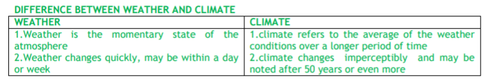
1. The monsoon regime emphasizes the unity of India with the rest of southeast Asian region.
2. This view of broad unity of the monsoon type of climate should not, however, lead one to ignore its regional variations which differentiate the weather and climate of different regions of India.
3. The climate of Kerala and Tamil Nadu in the south are so different from that of Uttar Pradesh and Bihar in the north, and yet all of these have a monsoon type of climate.
DIVERSITY OF CLIMATE
The climate of India has many regional variations expressed in the pattern of
1. winds, 2. temperature 3. rainfall, 4. rhythm of seasons 5. degree of wetness or dryness.
TEMPERATURE VARIATION
1. While in the summer the mercury occasionally touches 55°C in the western Rajasthan, it drops down to as low as minus 45°C in winter around Leh.
2. Churu in Rajasthan may record a temperature of 50°C or more on a June day while the mercury hardly touches 19°C in Tawang (Arunachal Pradesh)on the same day.
3. On a December night, temperature in Drass (Jammu and Kashmir) may drop down to minus 45°C while Thiruvananthapuram or Chennai on the same night records 20°C or 22°C.
4. In Kerala and in the Andaman Islands, the difference between day and night temperatures may be hardly seven or eight degree Celsius. But in the Thar desert, if the day temperature is around 50°C, at night, it may drop down considerably up to 15°-20°C.
THE REGIONAL VARIATIONS IN PRECIPITATION.
1. While snowfall occurs in the Himalayas, it only rains over the rest of the country.
2 .While Cherrapunji and Mawsynramin the Khasi Hills of Meghalaya receive rainfall over 1,080 cm in a year, Jaisalmer in Rajasthan rarely gets more than 9 cm of rainfall during the same period.
3. Tura situated in the Garo Hills of Meghalaya may receive an amount of rainfall in a single day which is equal to 10 years of rainfall at Jaisalmer.
4. While the annual precipitation is less than 10 cm in the northwest Himalayas and the western deserts, it exceeds 400 cm in Meghalaya.
5. The Ganga delta and the coastal plains of Orissa are hit by strong rain-bearing storms almost every third or fifth day in July and August while the Coromandal coast, a thousand km to the south, goes generally dry during these months.
6. Most parts of the country get rainfall during June-September, but on the coastal areas of Tamil Nadu, it rains in the beginning of the winter season.
FACTORS DETERMINING THE CLIMATE OF INDIA
India‘s climate is controlled by a number of factors which can be broadly divided into two groups — factors related to location and relief, and factors related to air pressure and winds.
Factors related to Location and Relief
Latitude :
The Tropic of Cancer passes through the central part of India in east-west direction.
Thus, northern part of the India lies in sub-tropical and temperate zone and the part lying south of the Tropic of Cancer falls in the tropical zone.
The tropical zone being nearer to the equator, experiences high temperatures throughout the year with small daily and annual range.
Area north of the Tropic of Cancer being away from the equator, experiences extreme climate with high daily and annual range of temperature.
The Himalayan Mountains :
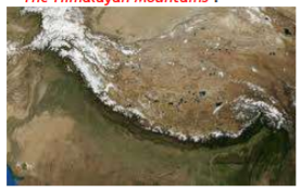
1. Himalayas in the north along with its extensions act as an effective climatic divide.
2. The towering mountain chain provides an invincible shield to protect the subcontinent from the cold northern winds.
3. The Himalayas also trap the monsoon winds, forcing them to shed their moisture within the subcontinent.
Distribution of Land and Water:
As compared to the landmass, water heats up or cools down slowly. This differential heating of land and sea creates different air pressure zones in different seasons in and around the Indian subcontinent. Difference in air pressure causes reversal in the direction of monsoon winds.
Distance from the Sea :With a long coastline, large coastal areas have an equable climate. Areas in the interior of India are far away from the moderating influence of the sea. Such areas have extremes of climate. That is why, the people of Mumbai and the Konkan coast have hardly any idea of extremes of temperature and the seasonal rhythm of weather.
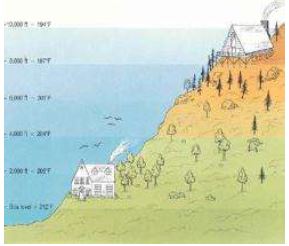
Altitude :As the altitude increases the temperature falls down, that is why Himalayas experience cold climate and north Indian plains plain experience hot climate
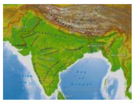
Relief :The physiography or relief of India also affects the temperature, air pressure, direction and speed of wind and the amount and distribution of
rainfall.
The windward sides of Western Ghats and Assam receive high rainfall during June-September whereas the southern plateau remains dry due to its leeward situation along the Western Ghats.
Factors Related to Air Pressure and Wind To understand the differences in local climates of India, we need to understand the mechanism of the following three factors:
(i) Distribution of air pressure and winds on the surface of the earth.
(ii) Upper air circulation caused by factors controlling global weather and the inflow of different air masses and jet streams.
(iii) Inflow of western cyclones generally known as disturbances during the winter season and tropical depressions during the south-west monsoon period into India, creating weather conditions favorable to rainfall. The mechanism of these three factors can be understood with reference to winter and summer seasons of the year separately
Mechanism of Weather in the Winter Season
Surface Pressure and Winds :
1. In winter months, a high pressure centre in the region lying to the north of the Himalayas develops during winter.
2. This centre of high pressure gives rise to the flow of air at the low level from the north towards the Indian subcontinent, south of the mountain range.
3. The surface winds blowing out of the high pressure centre over Central Asia reach Indian the form of a dry continental air mass.
4.The position of this contact zone is not, however, stable. Occasionally, it may shift its position as East as the middle Ganga valley with the result that the whole of the northwestern and northern India up to the middle Ganga valley comes under the influence of dry northwestern winds.
5.The pattern of air circulation discussed above is witnessed only at the lower level of the atmosphere near the surface of the earth. Higher up in the lower troposphere,
6. About three km above the surface of the earth, a different pattern of air circulation is observed. The variations in the atmospheric pressure closer to the surface of the earth have no role to play in the making of upper air circulation.
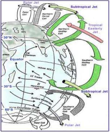
7. All of Western and Central Asia remain under the influence of westerly winds along the altitude of 9-13 km from west to east.
8. These winds blow across the Asian continent at latitudes north of the Himalayas roughly parallel to the Tibetan highlands. These are known as jet streams.
9. Tibetan highlands act as a barrier in the path of these jet streams. As a result, jet streams get bifurcated.
Western Cyclonic Disturbance and TropicalCyclones
1. The western cyclonic disturbances which enter the Indian subcontinent from the west and the northwest during the winter months,
2. Originate over the Mediterranean Sea and are brought into India by the westerly jet stream.
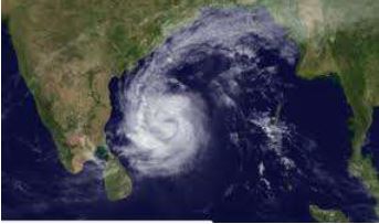
3. Tropical cyclones originate over the Bay of Bengal and the Indian ocean. These tropical cyclones have very high wind velocity and heavy rainfall and hit the Tamil Nadu, Andhra Pradesh and Orissa coast
Mechanism of Weather in the Summer Season
Surface Pressure and Winds
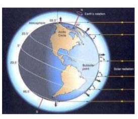
1. As the summersets in and the sun shifts northwards,
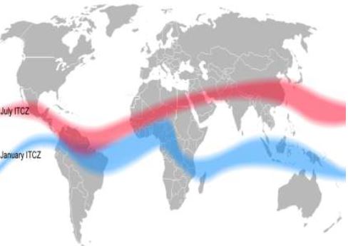
2. By the middle of July, the low pressure belt nearer the surface [termed as Inter Tropical Convergence Zone (ITCZ)]shifts northwards, roughly parallel to the Himalayas between 20° N and 25° N.
3. By this time, the westerly jet stream withdraws from the Indian region
4. It is generally believed that there is a cause and effect relationship between the two. The ITCZ being a zone of low pressure, attracts inflow of winds from different directions.
5. The maritime tropical Air mass (mT) from the southern hemisphere, after crossing the equator, rushes to the low pressure area in the general south westerly direction.
6. It is this moist air current which is popularly known as the southwest monsoon.
Jet Streams and Upper Air
Circulation :
1. The pattern of pressure and winds as mentioned above is formed only at the level of the troposphere.
2. An easterly jet stream flows over the southern part of the Peninsula in June, Inter Tropical Convergence Zone (ITCZ) The Inter Tropical Convergence Zone (ITCZ) is a low pressure zone located at the equator where trade winds converge, and so, it is a zone where air tends to ascend. In July, the ITCZ is located around 20°N-25°N latitudes (over the Gangetic plain), sometimes called the monsoon trough. This monsoon trough encourages the development of thermal low over north and northwest India. Due to the shift of ITCZ, the trade winds of the southern hemisphere cross the equator between 40° and 60°E longitudes and start blowing from southwest to northeast due to the Coriolis force. It becomes southwest monsoon. In winter, the ITCZ moves southward, and so the reversal of winds from northeast to south and southwest, takes place. They are called northeast monsoons.
Easterly Jet Stream and Tropical Cyclones : The easterly jet stream steers the tropical depressions into India. These depressions play a significant role in the distribution of monsoon rainfall over the Indian subcontinent.
THE NATURE OF INDIAN MONSOON
(i) The onset of the monsoon.
(ii) Rain-bearing systems (e.g. tropical cyclones) and the relationship between their frequency and distribution of monsoon rainfall.
(iii) Break in the monsoon.
Onset of the Monsoon
1. the differential heating of land and sea during the summer months is the mechanism which sets the stage for the monsoon winds to drift towards the subcontinent.
2. During April and May when the sun shines vertically over the Tropic of Cancer, the large landmass in the north of Indian ocean gets intensely heated.
3. This causes the formation of an intense low pressure in the northwestern part of the subcontinent. Since he pressure in the Indian Ocean in the south of the landmass is high as water gets heated. slowly, the low pressure cell attracts the southeast trades across the Equator.
4. These conditions help in the northward shift in the position of the ITCZ.
5. The southwest monsoon may thus, be seen as a continuation of the southeast trades deflected towards the Indian subcontinent after crossing the Equator.
6. These winds cross the Equator between 40°E and 60°E longitudes.
The easterly jet stream sets in along 15°N latitude only after the western jet stream has withdrawn itself from the region. This easterly jet stream is held responsible for the burst of the monsoon in India.
Entry of Monsoon into India :The southwest monsoon sets in over the Kerala coast by 1st
June and moves swiftly to reach Mumbai and Kolkata between 10th and 13th June. By midJuly, southwest monsoon engulfs the entire subcontinent Rain-bearing Systems and Rainfall Distribution
1. Bay Of Bengal Branch
2. Arabian sea branch
The rainfall distribution is based on two factors:
(i) The offshore meteorological conditions.
(ii) The position of the equatorial jet stream along the eastern coast of Africa
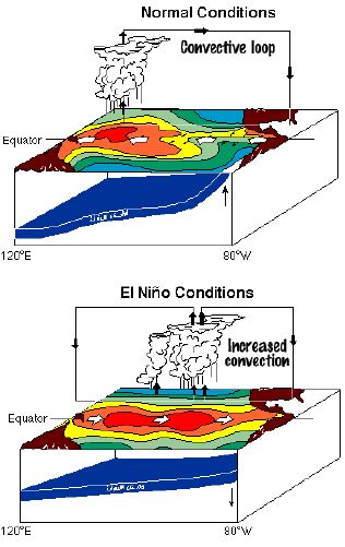
EI-Nino and the Indian Monsoon
EI-Nino is a complex weather system that appears once every three to seven years, bringing drought, floods and other weather extremes to different parts of the world.
The system involves oceanic and atmospheric phenomena with the appearance of warm currents off the coast of Peru in the Eastern Pacific and affects weather in many places including India. EINino is merely an extension of the warm equatorial current which gets replaced temporarily by cold Peruvian current or Humbolt current (locate these currents in your atlas). This current increases the temperature of water on the Peruvian coast by 10°C.
This results in:
(i) the distortion of equatorial atmospheric circulation;
(ii) irregularities in the evaporation of sea water;
(iii) reduction in the amount of planktons which further reduces the number of fish in the sea.
The word EI-Nino means ‗Child Christ‘ because this current appears around Christmas in December.
December is a summer month in Peru (Southern Hemisphere).
EI-Nino is used in India for forecasting long range monsoon rainfall. In 1990-91, there was a wild EINino event and the onset of southwest monsoon was delayed over most parts of the country ranging from five to twelve days.
Break in the Monsoon
During the south-west monsoon period after having rains for a few days, if rain fails to occur for one or more weeks, it is known as break in the monsoon. These dry spells are quite common during the rainy season. These breaks in the different regions are due to different reasons:
(i) In northern India rains are likely to fail if the rain-bearing storms are not very frequent along the monsoon trough or the ITCZ over this region.
(ii) Over the west coast the dry spells are associated with days when winds blow parallel to the coast.
THE RHYTHM OF SEASONS
The climatic conditions of India can best be described in terms of an annual cycle of seasons. The meteorologists recognise the following four seasons :
(i) the cold weather season
(ii) the hot weather season
(iii) the southwest monsoon season
(iv) the retreating monsoon season.
The Cold Weather Season
Temperature :
1. Found from November to February
2. December and January are the coldest months in the northern plain.
3. The mean daily temperature remains below 21°C , over most parts of northern India.
4. The night temperature may be quite low, sometimes going below freezing point in Punjab and Rajasthan.
There are three main reasons for the excessive cold in north India during this season :
(i) States like Punjab, Haryana and Rajasthan being far away from the moderating influence of sea experience continental climate.
(ii) The snowfall in the nearby Himalayan ranges creates cold wave situation; and
(iii) Around February, the cold winds coming from the Caspian Sea and Turkmenistan bring cold wave along with frost and fog over the northwestern parts of India.
Pressure and Winds :
1. By the end of December (22nd December), the sun shines vertically over the Tropic of Capricorn in the southern hemisphere.
2. The weather in this season is characterized by feeble high pressure conditions over the northern plain. In south India, the air pressure is slightly lower respectively
3. As a result, winds start blowing from northwestern high pressure zone to the low air pressure zone over the Indian Ocean in the south. Due to low pressure gradient, the light winds with a low velocity of about 3-5 km per hour begin to blow outwards.
4. By and large, the topography of the region influences the wind direction. They are westerly or northwesterly down the Ganga Valley. They become northerly in the Ganga-Brahmaputra delta. Free from the influence of topography, they are clearly northeasterly over the Bay of Bengal.
5. During the winters, the weather in India is pleasant.
6. The pleasant weather conditions, however, at intervals, get disturbed by shallow cyclonic depressions originating over the east Mediterranean Sea and travelling eastwards across West Asia, Iran, Afghanistan and Pakistan before they reach the northwestern parts of India.
Rainfall :1. Winter monsoons do not cause rainfall as they move from land to the sea.
2. It is because firstly, they have little humidity;
3. secondly, due to anti cyclonic circulation on land, the possibility of rainfall from them reduces.
So, most parts of India do not have rainfall in the winter season.
However, there are some exceptions to it:
(i) In northwestern India, some weak temperate cyclones from the Mediterranean sea cause rainfall in Punjab, Haryana, Delhi and western Uttar Pradesh. Although the amount is meager, it is highly beneficial for rabi crops. The precipitation is in the form of snowfall in the lower Himalayas. It is this snow that sustains the flow of water in the Himalayan rivers during the summer months. The precipitation goes on decreasing from west to east in the plains and from north to south in the mountains.
(ii) Central parts of India and northern parts of southern Peninsula also get winter rainfall occasionally.
(iii) Arunachal Pradesh and Assam in the northeastern parts of India also have rains between 25 mm and 50 mm during these winter months.
(iv) During October and November, northeast monsoon while crossing over the Bay of Bengal, picks up moisture and causes torrential rainfall over the Tamil Nadu coast, southern Andhra Pradesh, southeast Karnataka and south east Kerala.
The Hot Weather Season
Temperature:
1.With the apparent northward movement of the sun towards the Tropic of Cancer in March, temperatures start rising in north India.
2.April, May and June are the months of summer in north India. In most parts of India, temperatures recorded are between 30°-32°C.
3. In March, the highest day temperature of about 38°C occurs in the Deccan Plateau while in April, temperature ranging between 38°C and 43°C are found in Gujarat and Madhya Pradesh.
4. In May, the heat belt moves further north, and in the north-western part of India, temperatures around 48°C are not uncommon
5. temperatures remain between 26°C and 32°C. Due to altitude, the temperatures in the hills of= Western Ghats remain below 25°C.
Pressure and Winds :
1.The summer months are a period of excessive heat and falling air pressure in the northern half of the country.
2. Roughly, this elongated low pressure monsoon trough extends over the Thar desert in the northwest to Patna and Chotanagpur plateau in the east southeast
3.The location of the ITCZ attracts a surface circulation of the winds which are southwesterly on the west coast as well as along the coast of West Bengal and Bangladesh.
4.They are easterly or southeasterly over north Bengal and Bihar. .
5.In the heart of the ITCZ in the northwest, the dry and hot winds known as ‗Loo‘, blow in the afternoon, and very often, they continue to well into midnight.
6. Dust storms in the evening are very common during May in Punjab, Haryana, Eastern Rajasthan and Uttar Pradesh.
7. These temporary storms bring a welcome respite from the oppressing heat since they bring with them light rains and a pleasant cool breeze.
8. Occasionally, the moisture-laden winds are attracted towards the periphery of the trough.
9. A sudden contact between dry and moist air masses gives rise to local storms of great intensity.
10. These local storms are associated with violent winds, torrential rains and even hailstorms.
Some Famous Local Storms of Hot Weather Season
(i) Mango Shower : Towards the end of summer, there are pre-monsoon showers which are a
common phenomena in Kerala and coastal areas of Karnataka. Locally, they are known as mango showers since they help in the early ripening of mangoes.
(ii) Blossom Shower : With this shower, coffee flowers blossom in Kerala and nearby areas.
(iii) Nor Westers :These are dreaded evening thunderstorms in Bengal and Assam. Their notorious nature can be understood from the local nomenclature of ‗Kalbaisakhi‘, a calamity of the month of Baisakh.
(iv) These showers are useful for tea, jute and rice cultivation. In Assam, these storms are known as ―BardoliChheerha‖.
(v) Loo : Hot, dry and oppressing winds blowing in the Northern plains from Punjab to Bihar with higher intensity between Delhi and Patna.
THE SOUTHWEST MONSOON SEASON
1.Due to high temperature there is lo to attract the trade winds of Southern Hemisphere coming from the Indian Ocean.
2.These southeast trade winds cross the equator and enter the Bay of Bengal and the Arabian Sea,
3.After crossing the equator, they follow a southwesterly direction. That is why they are known as southwest monsoons.
4.The rain in the southwest monsoon season begins rather abruptly. One result of the first rain is that it brings down the temperature substantially.
5.This sudden onset of the moisture-laden winds associated with violent thunder and lightning, is often termed as the ―break‖ or ―burst‖ of the monsoons.
The monsoon approaches the landmass in two branches:
(i) The Arabian Sea branch
(ii) The Bay of Bengal branch
Monsoon Winds of the Arabian Sea
The monsoon winds originating over the Arabian Sea further split into three branches:
(i) Its one branch is obstructed by the Western Ghats. These winds climb the slopes of the Western Ghats from900-1200 m. Soon, they become cool, and as a result, the windward side of the Sahyadris and Western Coastal Plain receive very heavy rainfall ranging between 250 cm and 400 cm. After crossing the Western Ghats, these winds descend and get heated up.
(ii) Another branch of the Arabian sea monsoon strikes the coast north of Mumbai. Moving along the
Narmada and Tapi river valleys, these winds cause rainfall in extensive areas of central India. The Chotanagpur plateau gets 15 cm rainfall from this part of the branch. Thereafter, they enter the Ganga plains and mingle with the Bay of Bengal branch.
(iii) A third branch of this monsoon wind strikes the Saurashtra Peninsula and the Kachchh. It then passes over west Rajasthan and along the Aravalis, causing only a scanty rainfall. In Punjab and Haryana, it too joins the Bay of Bengal branch. These two branches, reinforced by each other, cause rains in the western Himalayas,
Monsoon Winds of the Bay of Bengal
1.The Bay of Bengal branch strikes the coast of Myanmar and part of south east Bangladesh. But the Arakan Hills along the coast of Myanmar deflect a big portion of this branch towards the Indian subcontinent.
2.The monsoon, therefore, enters West Bengal and Bangladesh from south and southeast instead of from the south-westerly direction. From here, this branch splits into two under the influence of the Himalayas and the thermal low is northwest India. Its one branch moves westward along the Ganga plains reaching as far as the Punjab plains. The other branch moves up the Brahmaputra valley in the north and the northeast, causing widespread rains. Its sub-branch strikes the Garo and Khasi hills of Meghalaya. Mawsynram, located on the crest of Khasi hills, receives the highest average annual rainfall in the world.
Here it is important to know why the Tamil Nadu coast remains dry during this season.
There are two factors responsible for it:
(i) The Tamil Nadu coast is situated parallel to the Bay of Bengal branch of southwest monsoon.
(ii) It lies in the rain shadow area of the Arabian Sea branch of the south-west monsoon.
Characteristics of Monsoonal Rainfall
(i) Rainfall received from the southwest monsoons is seasonal in character, which occurs between June and September.
(ii) Monsoonal rainfall is largely governed by relief or topography. For instance the windward side of the Western Ghats register a rainfall of over 250 cm. Again, the heavy rainfall in the north -eastern states can be attributed to their hill ranges and the Eastern Himalayas.
(iii) The monsoon rainfall has a declining trend with increasing distance from the sea. Kolkata receives 119 cm during the southwest monsoon period, Patna 105 cm, Allahabad 76 cm and Delhi 56 cm.
(iv) The monsoon rains occur in wet spells of few days duration at a time. The wet spells are interspersed with rainless, interval known as ‗breaks‘. These breaks in rainfall are related to the cyclonic depressions mainly formed at the head of the Bay of Bengal, and their crossing into the mainland. Besides the frequency and intensity of these depressions, the passage followed by them determines the spatial distribution of rainfall.
(v) The summer rainfall comes in a heavy downpour leading to considerable run off and soil erosion.
(vi) Monsoons play a pivotal role in the agrarian economy of India because over three-fourths of the total rain in the country is received during the southwest monsoon season.
(vii) Its spatial distribution is also uneven which ranges from 12 cm to more than 250 cm.
(viii) The beginning of the rains sometimes is considerably delayed over the whole or a part of the country.
(viii) The rains sometimes end considerably earlier than usual, causing great damage to standing crops and making the sowing of winter crops difficult.
Season of Retreating Monsoon
1.October and November are known for retreating monsoons.
2.By the end of September, the southwest monsoon becomes weak as the low pressure trough of
3.the Ganga plain starts moving southward in response to the southward march of the sun.
4.The monsoon retreats from the western Rajasthan by the first week of September.
5. It withdraws from Rajasthan, Gujarat, Western Ganga plain and the Central Highlands by the end of the month.
6.By the beginning of October, the low pressure covers northern parts of the Bay of Bengal and by early November, it moves over Karnataka and Tamil Nadu.
7.By the middle of December, the centre of low pressure is completely removed from the Peninsula.
8.The retreating southwest monsoon season is marked by clear skies and rise in temperature.
9.The land is still moist. Owing to the conditions of high temperature and humidity, the weather becomes rather oppressive. This is commonly known as the ‗October heat‘
10.Here, October and November are the rainiest months of the year.
11.The widespread rain in this season is associated with the passage of cyclonic depressions which originate over the Andaman Sea and manage to cross the eastern coast of the southern Peninsula.
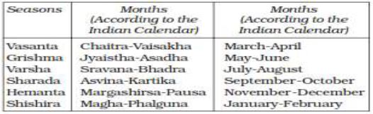
TRADITIONAL INDIAN SEASONS
Distribution of Rainfall
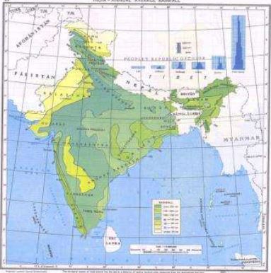
The average annual rainfall in India is about125 cm, but it has great spatial variations
Areas of High Rainfall : The highest rainfall occurs along the west coast, on the Western Ghats, as well as in the sub-Himalayan areas is the northeast and the hills of Meghalaya. Here the rainfall exceeds 200 cm. In some parts of Khasi and Jaintia hills, the rainfall exceeds 1,000 cm. In the Brahmaputra valley and the adjoining hills, the rainfall is less than 200 cm.
Areas of Medium Rainfall : Rainfall between 100-200 cm is received in the southern parts of Gujarat, east Tamil Nadu, northeastern Peninsula covering Odisha, Jharkhand, Bihar, eastern Madhya Pradesh, northern Ganga plain along the sub-Himalayas and the Cachar Valley and Manipur.
Areas of Low Rainfall: Western Uttar Pradesh, Delhi, Haryana, Punjab, Jammu and Kashmir, eastern Rajasthan, Gujarat and Deccan Plateau receive rainfall between 50-100 cm.
Areas of Inadequate Rainfall: Parts of the Peninsula, especially in Andhra Pradesh, Karnataka and Maharashtra, Ladakh and most of western Rajasthan receive rainfall below 50 cm. Snowfall is restricted to the Himalayan region. Identify the pattern of rainfall after consulting the rainfall map
Variability of Rainfall
A characteristic feature of rainfall in India is its variability.
The variability of rainfall is computed with the help of the following formula:
![]()
Here C.V. is the coefficient of variation.
1. The values of coefficient of variation show the change from the mean values of rainfall.
2. The actual rainfall in some places deviates from 20-50 per cent.
3. A variability of less than 25 per cent exists on the western coasts, Western Ghats, northeastern
Peninsula, eastern plains of the Ganga, north eastern India, Uttarakhand and Himachal Pradesh and south-western part of Jammu and Kashmir. These areas have an annual rainfall of over 100 cm.
4. A variability of over 50 per cent exists in the western part of Rajasthan, northern part of Jammu and Kashmir and interior parts of the Deccan plateau. These areas have an annual rainfall of less than 50 cm.
5. Rest of India have a variability of 25-50 per cent and these areas receive an annual rainfall between 50 -100 cm
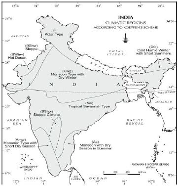
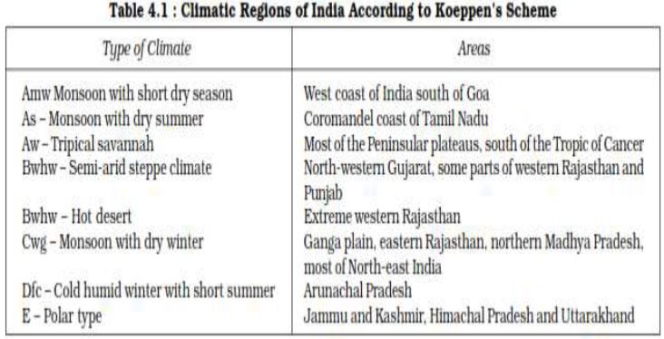
Climatic Regions of India
The whole of India has a monsoon type of climate. But the combination of elements of the weather, however, reveal many regional variations. These variations represent the subtypes of the monsoon climate. It is on this basis that the climatic regions can be identified.
Major climatic types of India based on Koeppen‘s scheme have been described below:
Koeppen based his scheme of Climatic classification on monthly values of temperature and precipitation. He identified five major climatic types, namely:
(i) Tropical climates, where mean monthly temperature throughout the year is over 18°C.
(ii) Dry climates, where precipitation is very low in comparison to temperature, and hence, dry. If dryness is less, it is semiarid (S); if it is more, the climate is arid(W).
(iii) Warm temperate climates, where mean temperature of the coldest month is between 18°C and minus 3°C.
(iv) Cool temperate climates, where mean temperature of the warmest month is over 10°C, and mean temperature of the coldest month is under minus 3°C.
(v)Ice climates, where mean temperature of the warmest month is under 10°C.
Koeppen used letter symbols to denote climatic types as given above. Each type is further subdivided into sub-types on the basis of seasonal variations in the distributional pattern of rainfall and temperature. He used S for semi-arid and W for arid and the following small letters to define subtypes:
f (sufficient precipitation),
m (rainforest despite a dry monsoon season),
w (dry season in winter),
h (dry and hot),
c (less than four months with mean temperature over10°C),
g (Gangetic plain).
Accordingly, India can be divided into eight climatic regions
Monsoons and the Economic Life in India
(i) Monsoon is that axis around which revolves the entire agricultural cycle of India. It is because about 64 percent people of India depend on agriculture for their livelihood and agriculture itself is based on southwest monsoon.
(ii) Except Himalayas all the parts of the country have temperature above the threshold level to grow the crops or plants throughout the year.
(iii) Regional variations in monsoon climate help in growing various types of crops.
(iv) Variability of rainfall brings droughts or floods every year in some parts of the country.
(v) Agricultural prosperity of India depends very much on timely and adequately distributed rainfall. If it fails, agriculture is adversely affected particularly in those regions where means of irrigation are Not developed.
(vi) Sudden monsoon burst creates problem of soil erosion over large areas in India.
(vii) Winter rainfall by temperate cyclones in north India is highly beneficial for rabi crops.
(viii) Regional climatic variation in India is reflected in the vast variety of food, clothes and house types.
GLOBAL WARMING
You know that change is the law of nature.
Climate has also witnessed change in the past at the global as well as at local levels. It is changing even now but the change is imperceptible. A number of geological evidences suggest that once upon a time,large part of the earth was under ice cover.
CBSE Class 11 Geography India Physical Environment Chapter 4 Climate Notes
Students can use these Revision Notes for India Physical Environment Chapter 4 Climate to quickly understand all the main concepts. This study material has been prepared as per the latest CBSE syllabus for Class 11. Our teachers always suggest that Class 11 students read these notes regularly as they are focused on the most important topics that usually appear in school tests and final exams.
NCERT Based India Physical Environment Chapter 4 Climate Summary
Our expert team has used the official NCERT book for Class 11 Geography to design these notes. These are the notes that definitely you for your current academic year. After reading the chapter summary, you should also refer to our NCERT solutions for Class 11. Always compare your understanding with our teacher prepared answers as they will help you build a very strong base in Geography.
India Physical Environment Chapter 4 Climate Complete Revision and Practice
To prepare very well for y our exams, students should also solve the MCQ questions and practice worksheets provided on this page. These extra solved questions will help you to check if you have understood all the concepts of India Physical Environment Chapter 4 Climate. All study material on studiestoday.com is free and updated according to the latest Geography exam patterns. Using these revision notes daily will help you feel more confident and get better marks in your exams.
FAQs
You can download the teacher prepared revision notes for CBSE Class 11 Geography Climate Vegetation And Soil Notes from StudiesToday.com. These notes are designed as per 2026-27 academic session to help Class 11 students get the best study material for Geography.
Yes, our CBSE Class 11 Geography Climate Vegetation And Soil Notes include 50% competency-based questions with focus on core logic, keyword definitions, and the practical application of Geography principles which is important for getting more marks in 2026 CBSE exams.
Yes, our CBSE Class 11 Geography Climate Vegetation And Soil Notes provide a detailed, topic wise breakdown of the chapter. Fundamental definitions, complex numerical formulas and all topics of CBSE syllabus in Class 11 is covered.
These notes for Geography are organized into bullet points and easy-to-read charts. By using CBSE Class 11 Geography Climate Vegetation And Soil Notes, Class 11 students fast revise formulas, key definitions before the exams.
No, all study resources on StudiesToday, including CBSE Class 11 Geography Climate Vegetation And Soil Notes, are available for immediate free download. Class 11 Geography study material is available in PDF and can be downloaded on mobile.