GEOGRAPHY
How Maps Help Us
Answer the following questions in brief:-
Q 1. What is a map?
Ans. A map is a representation of whole Earth or any part of it, drawn on some particular scale on a flat surface.
Q 2. What is a globe?
Ans. A globe is a small model of the big earth.
Q 3. Write the difference between a map and a globe.
Ans.
Globe Map
Globe is a true model of the earth. A map is drawn on a flat surface.
It is three dimensional and spherical in shape. Map is easier to handle than a globe.
Q 4. Why maps were made? Give their importance.
Ans. 1. The positions of the places are shown in the maps.
2. We can find the distance of one place to another with the help of maps.
3. The routes, rivers, physical features etc. can be easily located with the help of maps.
Q 5. Enlist the different types of maps.
Ans. 1. Physical maps 2. Historical maps
3. Distributional maps 4. Topographical maps
5. Atlas maps
Q 6. Make a chart of the conventional symbols.
Q 7. In coloured maps with which colour we show mountains, uplands, plains, rivers, forests and snow covered hills?
Ans.
Physical Feature Colour
Mountains Brown
Uplands Yellow
Plains Green
Rivers Blue
Forests Green
Snow covered hills White
Q 8. What is the use of directions in the maps?
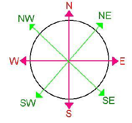
Ans. We locate the places with the help of directions. The top of a map is North direction. By this, we can find the other directions as well.

Q 9. How does scale of the map help us to study the maps?
Ans. We cannot show thousand kilometres distance on small maps. So, we show this on small scale. For example we can show 1000 km surface distance in proportion on 10 cm scale.
This scale will be as: - 1cm = 100 Km
Q 10. What is the importance of the key in the map?
Ans. We cannot show roads railways cities, rivers etc. in their actual sizes on maps. So, we use symbols to show these. These signs show natural and manmade features on the maps.
SECTION-A
VERY SHORT ANSWER QUESTIONS
1. The largest delta in the world is the
A. Lachaco
B. Grand ganga
C. Sundarban delta
D. Coromandel delta
2. The large landmasses are known as __________
3. What are plateaus?
4. What do you mean by the term Pamir knot?
5. Find the incorrect option
A. The cold weather season or winter.
B. The hot weather season or summer.
C. The North West monsoon season.
D. The retreating monsoon season.
SECTION-B
SHORT ANSWER TYPE QUESTIONS
6. Differentiate between equable climate and extreme climate.
7. Name the different types of vegetation found in India.
8. Read the source given below and answer the questions that follow: The Earth is the fifth largest planet in the solar system and is the third planet from the sun It is the only planet in the solar system that supports life .When seen from the outer space, the Earth looks blue. It is due to the presence of water on its surface. Therefore , the Earth is also known as the watery planet or blue planet .Another unique feature is that due to the temperature which the earth experiences , water is available in three forms _ solid , liquid ,and gas.
a) Name the three different forms in which water is available on the earth.
b) Why the earth is considered as watery planet?
c) Which is the fifth largest planet in the solar system?
SECTION-C
LONG ANSWER TYPE QUESTIONS
9. Classify mountains on the basis of origin. How are mountains different from plateaus?
10. What would have happened if there was no atmosphere and also write the importance of atmosphere?
Please click on below link to download CBSE Class 6 Social Science Geography Worksheet Set B

