

ICSE Solutions Voyage Class 7 Geography Chapter 6 Recording Of Weather have been provided below and is also available in Pdf for free download. The Voyage ICSE solutions for Class 7 Geography have been prepared as per the latest syllabus and ICSE books and examination pattern suggested in Class 7. Questions given in ICSE Voyage book for Class 7 Geography are an important part of exams for Class 7 Geography and if answered properly can help you to get higher marks. Refer to more Chapter-wise answers for ICSE Class 7 Geography and also download more latest study material for all subjects. Chapter 6 Recording Of Weather is an important topic in Class 7, please refer to answers provided below to help you score better in exams
Voyage Chapter 6 Recording Of Weather Class 7 Geography ICSE Solutions
Class 7 Geography students should refer to the following ICSE questions with answers for Chapter 6 Recording Of Weather in Class 7. These ICSE Solutions with answers for Class 7 Geography will come in exams and help you to score good marks
Chapter 6 Recording Of Weather Voyage ICSE Solutions Class 7 Geography
VALUES AND LIFE SKILLS
Many people leave their pets in parked cars. They think they will be gone for a few minutes, or it will be alright to leave a window open. The temperature inside a parked car can rise up to more than 50°C in a matter of few minutes, irrespective of it being a hot or a cloudy day.
Question. What would be the right thing to do if you see a pet locked inside a car on a hot day ?
Answer: Keeping a pet inside a closed vehicle is always risky. When conditions outside are warm, it can quickly turn fatal. Extreme heat can lead to permanent damage to organs or even cause them to die. We must all work together to save animals from such avoidable tragedies.
In simple words: Never leave pets in parked cars because they can quickly overheat and die. If you see an animal locked inside a car on a hot day, try to find the owner or call for help immediately.
Exam Tip: Highlighting the danger of extreme temperature build-up inside vehicles is key to answering questions on animal welfare and safety.
Exercises
A. Write true or false. Correct the false statements.
Question 1. A rise in temperature causes more condensation while a fall in temperature results in evaporation.
Answer: False.
Correct statement: A higher temperature increases evaporation, whereas a lower temperature leads to condensation.
In simple words: Warmth makes water turn into vapor, while cold temperatures turn vapor back into liquid.
Exam Tip: Remember that heating speeds up water turning into gas (evaporation), while cooling makes it turn back into water droplets (condensation).
Question 2. ‘4 o’clock showers’ are caused by cyclonic rainfall.
Answer: False.
Correct statement: Convectional currents are responsible for creating the daily 4 o'clock showers.
In simple words: These afternoon rains are caused by rising warm air currents, not by cyclones.
Exam Tip: Always associate "4 o'clock showers" with equatorial regions and convectional rainfall rather than frontal or relief rainfall.
Question 3. Heavy rainfall occurs on the leeward or rain shadow side of a highland.
Answer: False.
Correct statement: Very minimal rain falls on the rain shadow or leeward slope of a mountain.
In simple words: The backside of a mountain gets very little rain because the clouds have already lost most of their water on the other side.
Exam Tip: Remember that the windward side receives maximum rainfall, while the leeward side remains dry and is known as the rain shadow area.
Question 4. The direction of wind blowing on the surface of the earth is affected by the Coriolis force.
Answer: True.
In simple words: Earth's spinning motion creates a force that bends the path of the winds.
Exam Tip: Coriolis force deflects winds to the right in the Northern Hemisphere and to the left in the Southern Hemisphere.
Question 5. Cyclones and anticyclones are examples of variable winds.
Answer: True.
In simple words: Winds that change their path and do not blow in one fixed direction all the year round are called variable winds, which includes cyclones.
Exam Tip: Note that cyclones (low pressure centers) and anticyclones (high pressure centers) are classified as variable or local wind systems due to their changing nature.
B. Fill in the blanks.
Question 1. The temperature of a place depends upon its ________, ________, ________, ocean currents, ________, ________ and ________ and ________.
Answer: latitude, altitude, distance from the sea, winds, cloud cover, slope, aspect
In simple words: Many natural factors like height, wind, and distance from the ocean determine how hot or cold a place is.
Exam Tip: Learn all seven factors that influence local temperatures as they are frequently asked in short-answer questions.
Question 2. Pressure difference causes horizontal movement of air called ________ and vertical movement of air called ________.
Answer: wind, current
In simple words: When air moves sideways it is called wind, and when it moves straight up or down it is called a current.
Exam Tip: Understand the difference between horizontal air flow (wind) and vertical air flow (current) clearly.
Question 3. Humidity refers to the amount of moisture or ________ present in the air.
Answer: water vapour
In simple words: Humidity is just a measure of how much water gas is mixed into the air.
Exam Tip: Water vapour is the gaseous form of water in the air, which represents humidity levels.
Question 4. Planetary winds are also called permanent or ________ winds.
Answer: prevailing
In simple words: Winds that blow all year round in the same direction are known as prevailing or permanent winds.
Exam Tip: Remember that planetary, permanent, and prevailing are all terms used for the same global wind belts.
Question 5. The amount of cloud cover in the sky is expressed in ________ (shaded in different proportions).
Answer: discs
In simple words: Weather maps use small circles that are shaded in to show how much of the sky is filled with clouds.
Exam Tip: On weather maps, cloud cover is represented using divided circular shapes called discs, measured in oktas.
C. Answer the following questions in brief.
Question 1. What are the elements that determine weather and climate?
Answer: The key factors that control both weather and climate are identical. These include temperature, air pressure, atmospheric moisture, rain or snow, the path and velocity of wind, how cloudy the sky is, and sunlight.
In simple words: Both weather and climate are measured using the same things, like temperature, rain, wind, and how sunny or cloudy it is.
Exam Tip: Be sure to list all major elements - temperature, pressure, humidity, wind speed/direction, precipitation, and cloud cover - to score full marks.
Question 2. Name the factors that determine the temperature at a place.
Answer: A location's temperature is influenced by its distance from the equator, height above sea level, proximity to oceans, sea currents, wind patterns, clouds, as well as the angle and direction of its land slopes.
In simple words: Where a place is, how high up it is, how close it is to water, and how the wind blows all affect its temperature.
Exam Tip: Use geographical terms like "latitude" and "altitude" rather than "distance from equator" or "height" to present a professional answer.
Question 3. How do the following elements influence the weather of a place :
1. temperature
2. pressure?
Answer:
1. Temperature: As the air warms up, it expands and moves upward, causing a drop in atmospheric pressure. Conversely, cooler air contracts, grows heavier, and sinks, which raises the pressure. Hence, higher temperatures lead to lower air pressure, which explains why regions near the equator usually experience low-pressure conditions.
2. Pressure: This refers to the weight of the air pressing down on Earth. Temperature and pressure are inversely related; warmer weather brings lower pressure, while cooler weather brings higher pressure. This pressure imbalance generates winds horizontally and currents vertically, driving overall atmospheric circulation.
In simple words: 1. Hot air rises and makes pressure low, while cold air sinks and makes pressure high. 2. Air pressure is the weight of air pushing down. The difference in pressure creates wind and air currents.
Exam Tip: Clearly explain the inverse relationship between temperature and pressure, emphasizing that hot air rises (low pressure) and cold air sinks (high pressure).
Question 4. Name the various forms of precipitation.
Answer: Some of the primary types of precipitation include rain, drizzle, snowfall, sleet, and hail.
In simple words: Rain, snow, sleet, hail, and drizzle are all different ways water falls from the sky.
Exam Tip: Remember to list at least four distinct forms (like rain, snow, hail, and sleet) to secure full marks on listing questions.
Question 5. How is cloud cover shown on a weather map? Give examples.
Answer: To represent cloud cover on a meteorological map, circles or discs are used. These symbols are divided and shaded in parts of eight, also known as oktas, to indicate how much of the sky is obscured.
In simple words: Weather maps use small circles that are shaded in to show how much of the sky is filled with clouds. These are measured in eighths.
Exam Tip: Use the term "oktas" (eighths of the sky) when describing how cloud cover is measured and illustrated on maps.
D. Answer the following questions in one or two paragraph’s.
Question 1. How is weather different from climate?
Answer: Although weather and climate are connected concepts, they represent different things. Weather describes the day-to-day state of the atmosphere in a localized region, typically over twenty-four hours. On the other hand, climate represents the long-term average of these conditions over a much broader area, typically calculated over a span of thirty-five years.
In simple words: Weather is what is happening outside right now, like today's rain. Climate is the pattern of weather over a very long time, like 35 years.
Exam Tip: Highlight the contrast between short-term duration (24 hours) for weather and long-term duration (typically 35 years) for climate to get full marks.
Question 2. What is condensation? Explain these different forms of condensation: fog, mist, and dew.
Answer: The transformation of gaseous water vapour into small liquid droplets or ice crystals is known as condensation, which is the inverse of evaporation. While evaporation happens in dry air, condensation requires the air to be fully saturated with moisture.
During the night, when the air near the ground cools down past its dew point, fog and mist are created. Fog is much thicker than mist, making it hazardous as it blocks clear sight. Dew, however, develops during cold winter nights when temperatures fall significantly but remain above freezing point.
In simple words: Condensation is when gas turns into water. Fog is thick cloud on the ground that makes it hard to see, mist is a lighter version of fog, and dew is the water droplets on grass in winter.
Exam Tip: When defining dew, remember to specify that the temperature must be low but always above 0°C to distinguish it from frost.
Question 3. What do you understand by the term ‘4 o’clock showers’?
Answer: Near equatorial zones, intense heat leads to rapid evaporation of water. This hot air expands and ascends as convection currents. As the air climbs higher, it spreads out and cools down. This cooling triggers condensation, leading to torrential rainfall. This storm is marked by thunder and lightning, and because it typically happens near 4 p.m., it has earned the name of 4 o'clock showers.
In simple words: Near the equator, hot air rises up all day and cools down, bringing heavy rain with thunder almost every day at around 4:00 in the afternoon.
Exam Tip: Remember to list the sequential steps: high evaporation -> convection currents rising -> cooling and condensation -> heavy daily afternoon rain with thunder.
Question 4. What are planetary winds? Give a brief description of the Westerlies in the northern hemisphere.
Answer: Also known as prevailing or permanent winds, planetary winds blow consistently across the globe in fixed zones throughout the entire year. The Westerlies are active in the mid-latitude regions, situated between 30 degrees and 60 degrees. They flow from the subtropical high-pressure zones (known as horse latitudes) toward the polar regions. Because of the earth's rotation and the resulting Coriolis effect, these winds are redirected to blow from the southwest, earning them the name South-Westerlies in our northern hemisphere.
In simple words: Planetary winds are global winds that blow in the same pattern all year. Westerlies blow in the middle latitudes, and the spin of the Earth turns them into South-Westerlies in the northern part of the world.
Exam Tip: Specify the latitude range (30° to 60°) and reference the effect of the Coriolis force in deflecting the winds to obtain full marks.
Question 5. What are local winds? Give a few examples.
Answer: Winds that blow for brief intervals over restricted geographic regions are termed local winds. Examples of heated local winds include the Loo, Simoom, and Chinook. Conversely, the Bora, Mistral, Buran, and Pampero represent examples of chilly local winds.
In simple words: Local winds only blow for a short time over small areas. Some of these winds are hot, like the Loo, while others are cold, like the Mistral.
Exam Tip: Provide at least two warm and two cold examples of local winds to demonstrate a complete understanding of this concept.
E. With the help of your atlas,encylopaedias, and the Internet, find out about the climate of these places.
Question E. With the help of your atlas,encylopaedias, and the Internet, find out about the climate of these places.
1. Mumbai
2. Delhi
3. Kolkata
4. London
5. New York
6. Sydney
Answer:
1. Mumbai: This city experiences a tropical wet and dry climate. It remains warm and humid throughout the year, with extremely heavy rainfall during the monsoon months from June to September.
2. Delhi: This region features an overlapping humid subtropical and semi-arid climate. It has extremely hot summers, a brief but intense monsoon season, and cool, dry winters.
3. Kolkata: This city has a tropical wet-and-dry climate. It features warm, damp weather for most of the year, with heavy rainfall during the summer monsoons.
4. London: The area experiences a temperate oceanic climate, characterized by cool summers, mild winters, and moderate precipitation distributed fairly evenly throughout the year.
5. New York: This city has a humid subtropical climate. It experiences hot, humid summers and cold, snowy winters, with precipitation spread evenly across all seasons.
6. Sydney: This city features a humid subtropical climate with mild winters and warm summers. Rainfall is moderate and occurs throughout the year, with slightly higher amounts in the autumn months.
In simple words: Different cities have different climates. Mumbai and Kolkata are warm and wet, Delhi has very hot summers and cold winters, London has mild and rainy weather, New York has hot summers and snowy winters, and Sydney has comfortable, warm weather most of the year.
Exam Tip: When writing about climates of famous cities, classify them using key geographical terms such as "tropical wet and dry", "temperate oceanic", or "humid subtropical".
Question F. In your notebook, draw neat, labelled, coloured sketches of the three different types of rainfall. Alongside each diagram, briefly describe in your own words, how each type of rainfall occurs.
Answer:
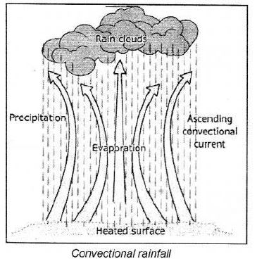
(a) Convectional Rainfall: In areas near the equator, intense solar heating drives very fast evaporation. The air above the ground gets hot, becomes lighter, and ascends as warm convection currents. As this air rises, it expands and loses heat. This cooling process leads to condensation and the formation of clouds, resulting in heavy afternoon downpours. Usually accompanied by loud thunder and bright lightning, this rain typically falls around 4:00 PM, giving it the name 4 o'clock showers.
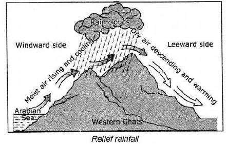
(b) Relief or Orographic Rainfall: This type of rain occurs when winds carrying moisture encounter a natural obstacle, like a mountain or plateau, and are forced to go upward. As the air travels up the slope, it expands and cools down, which causes water vapour to condense and form clouds. Once these clouds become fully saturated, they release water as rain on the windward slope.
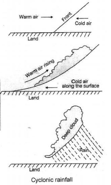
(c) Cyclonic or Frontal Rainfall: This rain happens when two distinct air masses - one warm and one cold - collide, creating a boundary called a front. Since cold air is heavier and more dense, it stays close to the Earth's surface, forcing the lighter warm air to rise over it. As the warm air is pushed upward, it expands and cools, causing its moisture to condense into deep clouds that produce rain.
In simple words: 1. Convectional rain is caused by warm air rising straight up, cooling, and creating daily afternoon storms. 2. Relief rain happens when moist wind hits a mountain and is pushed up, forming rain on that side. 3. Cyclonic rain happens when warm and cold air meet and the warm air is pushed up over the cold air, forming clouds and rain.
Exam Tip: Be ready to diagram all three types of rainfall: Convectional (rising thermal columns), Relief (orographic lift over high terrain), and Frontal (interaction of warm/cold air boundaries).
G. Picture study
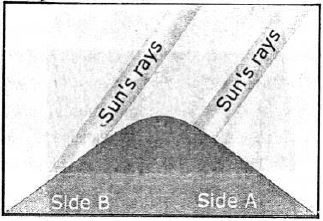
Question 1. The diagram alongside illustrates one of the factors that affect temperature. What is it ?
Answer: The concept depicted is known as aspect, which represents the orientation of a land slope relative to solar radiation. In the northern hemisphere of the Earth, slopes facing south get direct sunshine and are warmer, whereas those facing north stay much cooler. Conversely, in our southern hemisphere, slopes facing north receive more solar heat than those facing south.
In simple words: "Aspect" means which way a mountain slope faces. In the northern half of the world, south-facing slopes get more sun and are warmer, while north-facing slopes are colder.
Exam Tip: Be sure to define "aspect" clearly and contrast the differences between northern and southern hemispheres regarding north and south-facing slopes.
Question 2. Which side of the mountain is likely to have houses and be covered with trees ?
Answer: Side B is the side that is more likely to have forests and homes built on it.
In simple words: Side B will have more trees and houses because it is the safer and more suitable side.
Exam Tip: Remember that Side B represents the cooler, moisture-retaining slope (leeward/cooler side in certain hemispheres) which is more suitable for vegetation and human settlements.
Free study material for Geography
ICSE Voyage Solutions Class 7 Geography Chapter 6 Recording Of Weather
Students can now access the detailed Voyage Solutions for Chapter 6 Recording Of Weather on our portal. These solutions have been carefully prepared as per latest ICSE Class 7 syllabus. Each solution given above has been updated based on the current year pattern to ensure Class 7 students have the most updated Geography content.
Master Voyage Textbook Questions
Our subject experts have provided detailed explanations for all the questions found in the Voyage textbook for Class 7 Geography. We have focussed on making the concepts easy for you in Chapter 6 Recording Of Weather so that students can understand the concepts behind every answer. For all numerical problems and theoretical concepts these solutions will help in strengthening your analytical skill required for the ICSE examinations.
Complete Geography Exam Preparation
By using these Voyage Class 7 solutions, you can enhance your learning and identify areas that need more attention. We recommend solving the Geography Questions from the textbook first and then use our teacher-verified answers. For a proper revision of Chapter 6 Recording Of Weather, students should also also check our Revision Notes and Sample Papers available on studiestoday.com.
FAQs
You can download the verified Voyage solutions for Chapter 6 Recording Of Weather on StudiesToday.com. Our teachers have prepared answers for Class 7 Geography as per 2026-27 ICSE academic session.
Yes, our solutions for Chapter 6 Recording Of Weather are designed as per new 2026 ICSE standards. 40% competency-based questions required for Class 7, are included to help students understand application-based logic behind every Geography answer.
Yes, every exercise in Chapter 6 Recording Of Weather from the Voyage textbook has been solved step-by-step. Class 7 students will learn Geography conceots before their ICSE exams.
Yes, follow structured format of these Voyage solutions for Chapter 6 Recording Of Weather to get full 20% internal assessment marks and use Class 7 Geography projects and viva preparation as per ICSE 2026 guidelines.