

ICSE Solutions Voyage Class 7 Geography Chapter 14 Africa Location Area Political Physical Features have been provided below and is also available in Pdf for free download. The Voyage ICSE solutions for Class 7 Geography have been prepared as per the latest syllabus and ICSE books and examination pattern suggested in Class 7. Questions given in ICSE Voyage book for Class 7 Geography are an important part of exams for Class 7 Geography and if answered properly can help you to get higher marks. Refer to more Chapter-wise answers for ICSE Class 7 Geography and also download more latest study material for all subjects. Chapter 14 Africa Location Area Political Physical Features is an important topic in Class 7, please refer to answers provided below to help you score better in exams
Voyage Chapter 14 Africa Location Area Political Physical Features Class 7 Geography ICSE Solutions
Class 7 Geography students should refer to the following ICSE questions with answers for Chapter 14 Africa Location Area Political Physical Features in Class 7. These ICSE Solutions with answers for Class 7 Geography will come in exams and help you to score good marks
Chapter 14 Africa Location Area Political Physical Features Voyage ICSE Solutions Class 7 Geography
Think and Answer
Question. Why did Africa remain unexplored for a long time?
Answer: The equator runs right through the center of Africa. Most of this land lies in the tropics. This makes it the warmest continent on Earth. Travelers faced a lot of trouble while trying to explore it. In the north, they met the Sahara, which is the biggest desert on Earth. This desert was too dry and hot to pass through. Most of the continent is made of high, wavy flatlands called plateaus. Because of this, it was very hard for people to travel from the coast into the deeper parts. The rivers also have many fast waters and waterfalls. This made it unsafe for boats to travel on them. In other areas, thick rainforests and wet swamps were full of harmful bugs. Bites from tsetse flies and other insects made explorers too scared to go into the center of Africa.
In simple words: Africa was hard to explore because of its boiling hot weather, huge dry deserts, rough rivers, and thick forests full of dangerous insects.
Exam Tip: Remember to write about different physical barriers like the Sahara desert, steep plateaus, waterfalls in rivers, and thick forests with tsetse flies to get full marks.
Discuss
Question. Deforestation rate in Africa is twice the average for the rest of the world with more than four million hectares of primary forest disappearing every year. What could be the reasons for this?
Answer: The main causes are:
1. Clearing wild woodlands to grow crops for both family food and business sales.
2. Cutting down trees to sell the wood.
3. Other acts like raising farm animals, planting cash crops, and building dams, roads, and mines.
In simple words: Africa is losing its forests very fast because people cut down trees to farm, sell wood, and build roads or mines.
Exam Tip: Clearly separate the farming reasons, commercial logging, and development activities to score full points.
Values and Life Skills
Question. The Sahara Desert forms a large part of Africa. This desert extends from the Atlantic in the west to the Red Sea in the east. Suppose you were going to the Sahara Desert. List the things you would take with you. What kind of problems are you likely to face? How would you cope with them?
Answer:
PREPARING FOR DESERT EMERGENCIES
(a) Wear clothing that minimizes sweat loss: Cover your body with loose, light clothes to save water. This stops sweat from drying too fast on your skin, which keeps you hydrated.
(b) Bring lots of extra water: Carry much more water than you think you need. In high heat, you sweat out almost a liter every hour. If things go wrong, extra water will save you.
1. Split your water into different bottles. If one leaks, you still have the rest.
2. Keep extra water in a cool, dark place inside your car, out of the sun.
(c) Bring food that packs the most nutrition in the least size and weight: Take light foods that give a lot of energy, like nuts, dried fruit, or food bars. If your car breaks down, you will have to walk. You do not want to carry heavy things.
(d) Pack survival equipment: Here are the bare essentials for a survival kit:
1. Strong emergency blankets.
2. Cords or ropes.
3. Tablets to clean dirty water.
4. A first-aid kit.
5. Tools to start a fire.
6. A strong flashlight or headlamp that uses LED bulbs.
7. A pocket knife.
8. A compass.
9. A small mirror to make light signals.
10. Goggles and a face mask to keep dust out of your eyes and mouth.
SURVIVAL TACTICS
(a) Become nocturnal: Travel only at night when it is cool. Walking in the daytime is too hot and makes you lose too much water. This saves about three liters of water every day.
(b) Stay in a shelter during the day: Rest in the shade when the sun is up. If there is no car, tie ropes between two points. Hang an emergency blanket over them. Put some dry twigs on top, and add a thin shiny sheet on top of that. This traps air and keeps you cool.
(c) Signal for help: Light a fire to let rescuers find you. It makes smoke by day and bright light at night. Keep a mirror close by so you can bounce sunlight at planes or cars.
(d) Decide whether to stay in place: If you have water and people are looking for you, do not move. Walking in the heat drains your energy and water very fast. Only walk to find water if your supply is very low.
(e) Find water sources: Look for water in rocks after a rain. Otherwise, search for underground water:
1. Follow animal footsteps going down, flying bugs, or birds flying in circles.
2. Walk toward green plants, especially those with big leaves.
RECOGNIZING DANGERS
(a) Watch out for signs of dehydration: Do not try to save water by drinking less. Drink whenever you need to. Watch out for these warning signs:
1. Dark-colored or smelly urine.
2. Very dry skin.
3. Feeling dizzy.
4. Passing out.
(b) Rest if you experience heat exhaustion: If you feel sick or dizzy, or if your skin is cold and wet, find shade right away. Treat it like this:
1. Loosen or take off extra clothes.
2. Drink sports drinks or water mixed with a little salt.
3. Put a wet cloth on your body to cool down.
(c) Stay away from dangerous animals: Most wild beasts and snakes will avoid you if you leave them alone. Be careful not to trap or corner them.
In simple words: To survive in the Sahara desert, carry lots of water, wear light clothes, travel only at night, and learn how to make shade and signal for help.
Exam Tip: When listing items for a desert trip, remember to group them into preparation, survival actions, and danger signs to show a complete answer.
Exercises
A. Choose the correct answer
Question 1. The strait that separates Europe from Africa is the
(a) Palk Strait
(b) Bering Strait
(c) Strait of Gibraltar
(d) Strait of Magellan
Answer: (c) Strait of Gibraltar
In simple words: The narrow body of water that keeps Europe and Africa apart is called the Strait of Gibraltar.
Exam Tip: Always remember that the Strait of Gibraltar connects the Atlantic Ocean to the Mediterranean Sea and divides Spain from Morocco.
Question 2. A large portion of Africa lies in the
(a) desert
(b) tropics
(c) temperate region
(d) marshy land
Answer: (b) tropics
In simple words: Most of Africa's land is found in the warm tropical zone between the Tropic of Cancer and the Tropic of Capricorn.
Exam Tip: Remember that the equator goes right through the middle of Africa, which is why a huge part of the continent is in the tropics.
Question 3. The area in a desert where water can be found is called a/an
(a) pond
(b) well
(c) depression
(d) oasis
Answer: (d) oasis
In simple words: An oasis is a green spot in a dry desert where freshwater is available.
Exam Tip: Make sure you spell "oasis" correctly as it is a common one-word geographical term used in exams.
Question 4. The Sudd is a
(a) lake
(b) swamp
(c) gulf
(d) cape
Answer: (b) swamp
In simple words: The Sudd is a massive marshy area or swamp formed by the Nile River in South Sudan.
Exam Tip: The Sudd is one of the largest wetlands in the world, fed by the White Nile.
Question 5. The largest lake in Africa is
(a) Lake Chad
(b) Lake Tana
(c) Lake Victoria
(d) Lake Tanganyika
Answer: (c) Lake Victoria
In simple words: Lake Victoria is the biggest lake in Africa and is also the source of the famous Nile River.
Exam Tip: Lake Victoria is the second-largest freshwater lake in the world by surface area, after Lake Superior.
B. Identify who I am
Question 1. I am a country through which the Tropic of Capricorn passes:
Answer: Namibia
In simple words: Namibia is a country in Southern Africa that has the Tropic of Capricorn passing across it.
Exam Tip: Be sure to study the map of Africa to see which countries lie on the Tropic of Capricorn, the Equator, and the Tropic of Cancer.
Question 2. I am the southernmost tip of Africa:
Answer: Cape of Good Hope
In simple words: The Cape of Good Hope is the name of the land at the very bottom end of Africa.
Exam Tip: Cape Agulhas is the actual southernmost point geographically, but Cape of Good Hope is often the historical and standard answer in textbooks.
Question 3. I am a snow-capped mountain near the equator:
Answer: Mt. Kilimanjaro
In simple words: Mount Kilimanjaro is a very high volcano near the equator that has snow on its top.
Exam Tip: Mt. Kilimanjaro is the highest peak in Africa and is a dormant volcano in Tanzania.
Question 4. I am the longest river of Africa:
Answer: Nile
In simple words: The Nile is the longest river in Africa and also the entire world.
Exam Tip: Remember that the Nile River flows northward into the Mediterranean Sea.
Question 5. I am a river that flows into Lake Chad:
Answer: The Chari
In simple words: The Chari is a river that feeds water into Lake Chad in Central Africa.
Exam Tip: The Chari River provides most of the water that flows into Lake Chad.
Question 6. I am a lake that does not lie in the Great Rift Valley of Africa:
Answer: Lake Victoria
In simple words: Lake Victoria is a huge lake, but it is not part of the deep cracks called the Great Rift Valley.
Exam Tip: While most large African lakes are in the Rift Valley, Lake Victoria lies in a shallow basin between the two branches of the valley.
Question 7. I am a river that flows through the Namib Desert:
Answer: Okavango
In simple words: The Okavango is a river that flows into the dry Namib Desert area and ends in a land delta.
Exam Tip: The Okavango River is famous for forming a large inland delta instead of flowing into the ocean.
C. Match the following
Question. Match the following items of Column A with Column B:
| Column A | Column B |
|---|---|
| 1. Egypt | (i) Accra |
| 2. Kenya | (ii) Tripoli |
| 3. South Africa | (iii) Addis Ababa |
| 4. Ethiopia | (iv) Cairo |
| 5. Ghana | (v) Nairobi |
| 6. Libya | (vi) Pretoria |
Answer:
The correct matching is given below:
| Column A | Column B |
|---|---|
| 1. Egypt | (iv) Cairo |
| 2. Kenya | (v) Nairobi |
| 3. South Africa | (vi) Pretoria |
| 4. Ethiopia | (iii) Addis Ababa |
| 5. Ghana | (i) Accra |
| 6. Libya | (ii) Tripoli |
In simple words: This table pairs each country in Africa with its correct capital city. For example, Cairo is the capital of Egypt.
Exam Tip: Learning the capital cities of major African nations is a very common topic for match-the-following questions.
D. Give geographical reasons
Question 1. People faced many difficulties while exploring Africa.
Answer: People had a tough time exploring Africa. The massive Sahara Desert in the north was too hot and dry to cross. Also, most of the land consists of high, uneven plateaus, making it hard to go deep inside from the coast. The rivers have many waterfalls, so boats could not use them. Finally, the thick rainforests and swampy lands were full of dangerous flies and insects that scared travelers away.
In simple words: Exploring Africa was hard because of boiling deserts, rocky hills, rapid rivers with waterfalls, and thick forests filled with biting insects.
Exam Tip: Name at least three specific natural barriers like deserts, plateaus, and waterfalls to secure maximum marks.
Question 2. The rivers of Africa are not very suitable for navigation in their lower course.
Answer: African rivers have a lot of fast-flowing rapids and steep waterfalls. These rough waters make it dangerous and impossible for boats to travel safely near the end of their paths.
In simple words: Boats cannot travel easily on Africa's rivers because the water moves too fast and has too many waterfalls.
Exam Tip: Use keywords like "rapids" and "waterfalls" as these are the main reasons why the rivers are non-navigable.
Question 3. The river Nile flows through a desert and yet has water throughout the year.
Answer: The Nile River never runs dry because it starts from Lake Victoria. This lake is located in a tropical area where it rains heavily almost every day. This constant rain provides a steady supply of water to the river all year long.
In simple words: Even though the Nile goes through a dry desert, it stays full because its main water source is in a place where it rains a lot.
Exam Tip: Mentioning "Lake Victoria" and the "equatorial region" or "heavy rainfall" is key to scoring full marks on this question.
E. Answer the following questions briefly
Question 1. Give the latitudinal extent of Africa and explain why it is mostly a tropical continent.
Answer: Africa lies between the latitudes of \( 37^\circ \text{N} \) and \( 35^\circ \text{S} \). It is considered a tropical continent because the main body of its land sits between the Tropic of Cancer (\( 23\frac{1}{2}^\circ \text{N} \)) in the north and the Tropic of Capricorn (\( 23\frac{1}{2}^\circ \text{S} \)) in the south.
In simple words: Africa lies between \( 37^\circ \text{N} \) and \( 35^\circ \text{S} \). It is tropical because most of it sits between the hot northern and southern boundary lines of the tropics.
Exam Tip: Always state the exact coordinates (\( 37^\circ \text{N} \) to \( 35^\circ \text{S} \)) and name both Tropics to secure all points.
Question 2. Name three great explorers connected with the African continent.
Answer: Three important explorers of the continent are:
1. David Livingstone, who found the famous Victoria Falls in 1855.
2. Mungo Park, who explored the path of the Niger River.
3. Henry Morton Stanley, who traced the Congo River from Lake Tanganyika down to its mouth.
In simple words: Three key explorers of Africa were David Livingstone, Mungo Park, and Henry Morton Stanley, who mapped rivers and waterfalls.
Exam Tip: Pair each explorer's name with their specific discovery (e.g., Livingstone with Victoria Falls) to show a complete understanding.
Question 3. Name the major mountain ranges of Africa.
Answer: The Atlas Mountains are located in the north-west part of Africa. These are young fold mountains that run in three side-by-side lines: the Tell Atlas in the north, the High Atlas in the center, and the Sahara Atlas in the south. Their tallest peak is Mt Toubkal, which is covered in snow during most of the year.
In simple words: The main mountain range is the Atlas Mountains in the northwest, which has three parallel parts and a snowy peak called Mt Toubkal.
Exam Tip: Be sure to mention that the Atlas Mountains are "young fold mountains" and list their three parallel subdivisions.
Question 4. Name the lakes found in the Great Rift Valley.
Answer: The Great Rift Valley contains several major lakes, including Lake Malawi, Lake Mobutu, Lake Edward, and Lake Turkana.
In simple words: Lakes like Malawi, Mobutu, Edward, and Turkana are all located inside the Great Rift Valley.
Exam Tip: Memorize at least three of these lakes, as they are frequently asked in short-answer questions.
Question 5. How much time does it take the cocoa tree to yield cocoa pods?
Answer: The cocoa tree is a tropical evergreen that reaches a height of 4 to 9 meters. It takes around 5 to 7 years to start producing cocoa pods. These pods sprout directly on the main trunk and larger branches. Each pod measures about 18 to 25 cm in length and holds sweet pulp along with cocoa beans.
In simple words: A cocoa tree takes 5 to 7 years to grow its first pods, which grow on its trunk and big branches.
Exam Tip: Note that the time duration (5-7 years) and the location of the pods (trunk and main branches) are crucial details for full marks.
F. Answer the following questions in one or two paragraphs
Question 1. Elaborate on the achievements of the great explorers in opening up the continent of Africa.
Answer: Several famous explorers helped the world learn about Africa's interior. David Livingstone was the first European to find the grand Victoria Falls. Mungo Park mapped out the route of the Niger River. Henry Morton Stanley followed the Congo River from Lake Tanganyika all the way to its end at the ocean.
In simple words: Explorers like Livingstone, Park, and Stanley helped map Africa by finding major rivers and waterfalls.
Exam Tip: Clearly link each explorer to the specific geographical feature they mapped or discovered.
Question 2. Name the major physical divisions of Africa. Describe any one.
Answer: Africa has several main geographic regions:
1. The Atlas Mountains
2. The low central plateau
3. The high plateau of the south
4. The Great Rift Valley
5. The Nile and Congo-Zaire Basins
6. The coastal plains
DESCRIPTION OF THE ATLAS MOUNTAINS:
The Atlas Mountains are located in the northwestern part of Africa and are classified as young fold mountains. They run in three parallel rows - the Tell Atlas to the north, the High Atlas in the center, and the Sahara Atlas to the south. Mt Toubkal is their highest peak, which stays snow-covered for a large part of the year.
In simple words: Africa has different land areas like mountains, plateaus, valleys, and basins. The Atlas Mountains in the northwest are high fold mountains with three sections.
Exam Tip: Be prepared to describe any of the listed physical divisions, with the Great Rift Valley and the Atlas Mountains being the most common exam choices.
Question 3. Describe the three important deserts found in Africa.
Answer: The three main deserts in Africa are:
1. The Sahara: Situated on the low central plateau, it is the largest hot desert on Earth, spreading over 8.6 million square kilometers.
2. The Namib: This desert stretches along the western shores in the southwest of Africa.
3. The Kalahari: It is located in the southern region of the continent, making up a section of the high southern plateau.
In simple words: Africa has three main deserts: the massive Sahara in the north, the coastal Namib in the southwest, and the Kalahari in the south.
Exam Tip: Clearly state the location of each desert (north, southwest, and south) to make your answer distinct and easy to read.
Question 4. What is a rift valley? How is it formed?
Answer: A rift valley is a deep, narrow trench that is created when the earth's crust splits apart due to underground tectonic activity. The Great Rift Valley in Africa is over 5,000 kilometers long. It runs from Lake Malawi up to the Red Sea, and continues through the Gulf of Aqaba to the Dead Sea in Jordan. This valley contains several large freshwater lakes, such as Lake Malawi, Lake Tanganyika, and Lake Turkana.
In simple words: A rift valley is a long, deep crack in the ground made by movements of the Earth. Africa's rift valley is huge and holds many deep lakes.
Exam Tip: Be sure to mention how it is formed (crust movements and cracking) and its total length (5,000 km) for full marks.
Question 5. Give an account of the major lakes of Africa.
Answer: Africa has many important lakes. Lake Victoria is the biggest lake on the continent. The Chari River flows into Lake Chad, which is a shallow lake. Lake Tanganyika is famous for being one of the longest freshwater lakes on Earth. Additionally, the Great Rift Valley is home to other major lakes, such as Lake Malawi, Lake Mobutu, Lake Edward, and Lake Turkana.
In simple words: Africa has massive lakes. Lake Victoria is the largest, Lake Tanganyika is the longest, and many others lie in the Rift Valley.
Exam Tip: Divide your answer by highlighting the unique features of Lake Victoria (largest) and Lake Tanganyika (longest) to make your response stand out.
G. Map work
Question. On a blank outline map of Africa, mark the following:
1. The Cape of Good Hope
2. The Drakensberg Mountains
3. The Victoria Falls
4. The Atlas Mountains
5. The Nile River
6. The Libyan Desert
7. The Suez Canal
Answer:
The key geographical features are marked on the map of Africa below:
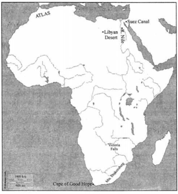
Here is where each feature is located on the map:
1. Cape of Good Hope: Located at the southernmost tip of Africa.
2. Drakensberg Mountains: Situated on the southeastern coast of South Africa.
3. Victoria Falls: Located on the Zambezi River in south-central Africa.
4. Atlas Mountains: Positioned in northwestern Africa, running through Morocco, Algeria, and Tunisia.
5. Nile River: Flows from east-central Africa northward into the Mediterranean Sea.
6. Libyan Desert: Lies in the northeastern region of Africa, forming part of the Sahara.
7. Suez Canal: Located at the northeast corner of Egypt, connecting the Mediterranean Sea to the Red Sea.
In simple words: This map shows the locations of important physical features in Africa, such as the Atlas Mountains in the north, the Nile River, and the Cape of Good Hope at the southern tip.
Exam Tip: When marking on an outline map, ensure that the Nile River is drawn flowing upwards (northwards) and the Suez Canal is marked exactly at the junction connecting Asia and Africa.
H. Picture Study
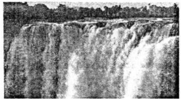
Question 1. Name the explorer who discovered it.
Answer: David Livingstone discovered these falls in the year 1855.
In simple words: David Livingstone was the first European explorer to find Victoria Falls in 1855.
Exam Tip: Always write both the name of the explorer (David Livingstone) and the year (1855) to secure full marks.
Question 2. On which river is this fall located?
Answer: The falls are situated on the Zambezi River.
In simple words: Victoria Falls is found on the Zambezi River.
Exam Tip: Remember that the Zambezi River is in Southern Africa, and spelling "Zambezi" correctly is essential.
Let's Do Something
Question. On a blank outline map of Africa:
(a) Mark with brown lines the Atlas and the Drakensberg Mountains.
(b) Shade with yellow and label the Sahara Desert and the Kalahari Desert.
(c) Shade with light brown the plateau region of Africa, the Ethiopian and Adamawa Highlands.
(d) Colour with blue and label neatly all the surrounding water bodies, oceans, seas, bays, gulfs, and straits.
Answer: Follow these steps to complete the map work:
(a) Draw thick brown lines on the northwestern edge of Africa to show the Atlas Mountains, and on the southeastern coast of South Africa for the Drakensberg Mountains.
(b) Color the large northern part of Africa with a light yellow pencil and label it "Sahara Desert". Also, shade the southern-central part of Africa in yellow and label it "Kalahari Desert".
(c) Use a light brown color to shade the vast interior plains (plateaus) of Central and Southern Africa. Specifically, shade the high mountainous region in East Africa as the "Ethiopian Highlands" and the high area in West-Central Africa as the "Adamawa Highlands".
(d) Use a blue color to shade the surrounding waters, including the Atlantic Ocean to the west, the Indian Ocean to the east, the Mediterranean Sea to the north, the Red Sea to the northeast, and the Gulf of Guinea on the west coast.
In simple words: Use brown for mountains, yellow for deserts, light brown for plateaus, and blue for oceans and seas to mark your Africa map.
Exam Tip: Always use a light touch with color pencils so that your labels remain clear and legible on the map.
Free study material for Geography
ICSE Voyage Solutions Class 7 Geography Chapter 14 Africa Location Area Political Physical Features
Students can now access the detailed Voyage Solutions for Chapter 14 Africa Location Area Political Physical Features on our portal. These solutions have been carefully prepared as per latest ICSE Class 7 syllabus. Each solution given above has been updated based on the current year pattern to ensure Class 7 students have the most updated Geography content.
Master Voyage Textbook Questions
Our subject experts have provided detailed explanations for all the questions found in the Voyage textbook for Class 7 Geography. We have focussed on making the concepts easy for you in Chapter 14 Africa Location Area Political Physical Features so that students can understand the concepts behind every answer. For all numerical problems and theoretical concepts these solutions will help in strengthening your analytical skill required for the ICSE examinations.
Complete Geography Exam Preparation
By using these Voyage Class 7 solutions, you can enhance your learning and identify areas that need more attention. We recommend solving the Geography Questions from the textbook first and then use our teacher-verified answers. For a proper revision of Chapter 14 Africa Location Area Political Physical Features, students should also also check our Revision Notes and Sample Papers available on studiestoday.com.
FAQs
You can download the verified Voyage solutions for Chapter 14 Africa Location Area Political Physical Features on StudiesToday.com. Our teachers have prepared answers for Class 7 Geography as per 2026-27 ICSE academic session.
Yes, our solutions for Chapter 14 Africa Location Area Political Physical Features are designed as per new 2026 ICSE standards. 40% competency-based questions required for Class 7, are included to help students understand application-based logic behind every Geography answer.
Yes, every exercise in Chapter 14 Africa Location Area Political Physical Features from the Voyage textbook has been solved step-by-step. Class 7 students will learn Geography conceots before their ICSE exams.
Yes, follow structured format of these Voyage solutions for Chapter 14 Africa Location Area Political Physical Features to get full 20% internal assessment marks and use Class 7 Geography projects and viva preparation as per ICSE 2026 guidelines.