

ICSE Solutions Voyage Class 7 Geography Chapter 16 Australia Location Area Political Physical Features have been provided below and is also available in Pdf for free download. The Voyage ICSE solutions for Class 7 Geography have been prepared as per the latest syllabus and ICSE books and examination pattern suggested in Class 7. Questions given in ICSE Voyage book for Class 7 Geography are an important part of exams for Class 7 Geography and if answered properly can help you to get higher marks. Refer to more Chapter-wise answers for ICSE Class 7 Geography and also download more latest study material for all subjects. Chapter 16 Australia Location Area Political Physical Features is an important topic in Class 7, please refer to answers provided below to help you score better in exams
Voyage Chapter 16 Australia Location Area Political Physical Features Class 7 Geography ICSE Solutions
Class 7 Geography students should refer to the following ICSE questions with answers for Chapter 16 Australia Location Area Political Physical Features in Class 7. These ICSE Solutions with answers for Class 7 Geography will come in exams and help you to score good marks
Chapter 16 Australia Location Area Political Physical Features Voyage ICSE Solutions Class 7 Geography
Discuss
Question. Why are the Eastern Highlands called the Great Dividing Range ?
Answer: These highlands earned this title because they form the primary drainage divide or watershed of the Australian continent. Most of the country's major river systems have their headwaters in these mountains. While streams like the Snowy River run rapidly down the steep eastern slopes, other long rivers including the Darling, Lachlan, and Murrumbidgee drain westward down the gentler slopes to merge with the Murray River.
In simple words: These mountains are called the Great Dividing Range because they act as a natural wall, parting the rivers that flow east toward the ocean from the rivers that flow west inland.
Exam Tip: Mention "watershed" or "drainage divide" and name-drop key rivers (like the Snowy, Darling, and Murray) to secure full marks.
Think and Answer
Question. Why can’t Australia’s exotic flora and fauna be found anyw here else in the world ?
Answer: Australia has been geographically separated from other major landmasses as an island continent for millions of years. This long isolation allowed its distinct plants and animals to evolve independently without outside interference, which is why they are unique to this country. Along with this exotic wildlife, Australia boasts pristine rainforests, ancient geological formations, low population density, and numerous World Heritage sites, creating a highly unique environment.
In simple words: Australia's plants and animals are unique because the country is a giant island that has been separated from the rest of the world for millions of years, letting its wildlife evolve on its own.
Exam Tip: Emphasize "geographic isolation" as the scientific reason why Australia's plant and animal species are unique.
Exercises
A. Fill in the blanks
Australia is situated between latitudes 10°S and 40°S, and longitudes 114°E and 154°E, placing this island continent completely within the Southern Hemisphere. While it is the world's sixth-largest nation by area, it holds the distinction of being the smallest continent. The name 'Australia' is derived from the Latin term 'Australis', which translates to 'Southern'. Officially designated as the Commonwealth of Australia, it is also widely known by popular nicknames such as the 'Island Continent' and the 'Land of Migrants'.
B. Choose the correct answer
Question 1. The Great Dividing Range is so called because:
(a) it divides Australia into two halves
(b) it is very high
(c) it acts as a watershed between the rivers flowing to the east and those flowing westwards
Answer: (c) it acts as a watershed between the rivers flowing to the east and those flowing westwards
In simple words: This mountain range acts like a natural ridge, separating the rivers that flow east to the Pacific Ocean from the ones that flow west into the interior.
Exam Tip: Use the term "watershed" to explain the geographical function of this mountain range.
Question 2. The Lake Eyre Basin is called an area of inland drainage because :
(a) the area keeps changing
(b) the rivers flowing in this area have no outlet to the sea
(c) it is a low-lying lake
Answer: (b) the rivers flowing in this area have no outlet to the sea
In simple words: It is called inland drainage because the rivers flowing here empty into Lake Eyre inside the continent instead of reaching the open ocean.
Exam Tip: Define "inland drainage" as a drainage basin where water does not reach the sea.
C. Answer the following questions in brief
Question 1. Name the water bodies that surround Australia.
Answer: The Australian continent is bounded by the Indian Ocean on its western coast and the South Pacific Ocean on its eastern coast.
In simple words: Australia is surrounded by the Indian Ocean to the west and the South Pacific Ocean to the east.
Exam Tip: Name both the Indian Ocean (west) and the South Pacific Ocean (east) to provide a complete answer.
Question 2. Identify and name the important line of latitude that passes through the middle of Australia.
Answer: The Tropic of Capricorn, located at 23 1/2° S latitude, passes directly through the center of the Australian continent.
In simple words: The Tropic of Capricorn (23.5 degrees South) is the major line of latitude that cuts right through the middle of Australia.
Exam Tip: State both the name "Tropic of Capricorn" and its latitudinal value (\( 23\frac{1}{2}^{\circ}\text{S} \)) to secure full marks.
Question 3. Why are the Eastern Highlands also called the Great Dividing Range?
Answer: This mountain system is called the Great Dividing Range because its peaks form Australia's primary watershed, separating rivers flowing toward different coasts. It is also the source region where many of the continent's most important river systems begin.
In simple words: The Eastern Highlands are called the Great Dividing Range because they act as a watershed that separates the rivers flowing east from those flowing west.
Exam Tip: Focus on the keyword "watershed" as the primary reason for this geographical name.
Question 4. What is an ‘aquifer’?
Answer: An aquifer is defined as a subsurface layer of permeable, porous rock or sediment that can hold, store, and transmit groundwater.
In simple words: An aquifer is an underground layer of rocky ground that soaks up and holds water like a giant sponge.
Exam Tip: Define an aquifer by highlighting its ability to both "store" water and "allow its passage" (permeability).
Question 5. What is meant by ‘inland drainage’? Give an example.
Answer: This term refers to a river system where the flowing streams do not have an outlet to the open ocean or sea. Instead, they empty their waters into internal lakes, swamps, or inland basins, such as the Lake Eyre basin in Australia.
In simple words: Inland drainage is when rivers do not flow into the ocean, but instead empty into an inland lake or dry up in the desert.
Exam Tip: Always use Lake Eyre as the classic example when discussing inland drainage basins in Australia.
Question 6. Which breed of sheep is mainly reared in Australia ?
Answer: The Merino sheep is the primary breed raised in Australia, renowned globally for producing the highest quality fine wool fleece.
In simple words: Merino sheep are the main breed raised in Australia because they grow the finest and softest wool.
Exam Tip: Clearly name the "Merino" breed and associate it with high-quality wool production.
Question 7. Identify the four main sheep-rearing states of Australia.
Answer: The four primary Australian states leading in sheep pastoralism are New South Wales, Victoria, Western Australia, and South Australia.
In simple words: The four main states for raising sheep are New South Wales, Victoria, Western Australia, and South Australia.
Exam Tip: Memorize these four key states, as they contain the largest sheep stations on the continent.
D. Answer the following questions in one or two paragraphs
Question 1. Mention two differences between the rivers that flow down the western and eastern slopes of the Great Dividing Range.
Answer: The Great Dividing Range acts as a major watershed, dividing Australia's drainage systems into two contrasting regions:
1. Eastern Slope Rivers: These rivers are relatively short, fast-flowing, and perennial (flow year-round) due to regular coastal rains. They drain directly into the Pacific Ocean.
2. Western Slope Rivers: These rivers are much longer, flowing inland across the dry central lowlands. Many of these streams do not reach the sea, instead draining into internal basins like Lake Eyre or forming part of the Murray-Darling system.
In simple words: Rivers on the east side of the mountains are short, flow all year round, and empty into the Pacific Ocean. Rivers on the west side are much longer, flow inland through dry areas, and often dry up before reaching the sea.
Exam Tip: Frame your answer by comparing length (short vs. long), flow duration (perennial vs. seasonal/intermittent), and destination (Pacific Ocean vs. inland basins).
Question 2. Explain an artesian basin and an artesian well.
Answer: An artesian basin is a geological structure consisting of a permeable, water-bearing rock layer (aquifer) sandwiched between two layers of impermeable, solid rock. This structure acts as a giant natural underground reservoir. Rain falling on higher ground seeps into the edges of the aquifer, where it is trapped under high pressure.
An artesian well is formed when a hole is bored through the upper impermeable rock layer directly into the pressurized aquifer. Because of the natural hydrostatic pressure built up within the basin, the trapped water rises to the surface on its own without needing a mechanical pump.
In simple words: An artesian basin is a layer of wet rock trapped between two solid rock layers underground. When a hole is drilled into this trapped water, the natural pressure squeezes the water up to the surface on its own, creating an artesian well.
Exam Tip: Clearly define the role of "impermeable rock layers" in trapping water and creating the "natural pressure" that drives artesian wells.
Question 3. Why is most of the underground water not suitable for human consumption agriculture?
Answer: A large portion of the groundwater stored in Australia's great artesian basins contains high concentrations of dissolved mineral salts. This high salinity makes the water unfit for drinking by humans and harmful to crops if used for agricultural irrigation, though it remains highly useful for watering livestock like sheep and cattle.
In simple words: Most of the underground water in Australia is too salty for humans to drink or for watering crops, though sheep and cattle can drink it.
Exam Tip: Cite "high salinity" or "saltiness" as the primary reason why artesian water cannot be used for drinking or irrigation.
Question 4. How are corals formed?
Answer: Corals are hard, limestone structures built from the calcium carbonate skeletons of tiny marine organisms called coral polyps. These polyps live in massive colonies in warm, shallow, and clear tropical waters. When the individual polyps die, their hard, protective skeletons remain cemented in place. Over thousands of years, new generations of polyps grow on top of these old skeletons. The gradual accumulation of these limestone layers forms vast, ridge-like underwater structures known as coral reefs.
In simple words: Corals are built by millions of tiny sea creatures called polyps that live in colonies. When they die, they leave behind hard skeletons, and new polyps grow on top of them, slowly building up coral reefs over time.
Exam Tip: Mention "coral polyps," "calcium carbonate skeletons," and "colonial living" to write a highly scientific answer.
Question 5. Write three interesting points about the Great Barrier Reef.
Answer: Three notable features of the Great Barrier Reef are:
1. Large Geographical Scale: This massive natural structure stretches over 2,300 km along the northeastern coast of Queensland, situated at distances ranging from 16 km to 240 km off the shore.
2. Biological Origin: It is built entirely from the accumulated calcium carbonate skeletons of millions of tiny living organisms called coral polyps.
3. Diverse Marine Ecosystem: As Australia's premier natural tourist destination, the warm, shallow waters behind the reef shelter an incredibly rich marine paradise, hosting hundreds of colorful tropical fish, mollusks, and crustaceans.
In simple words: 1. It is the world's largest coral reef, stretching over 2,300 km along Australia's northeast coast. 2. It is built by billions of tiny marine organisms called coral polyps. 3. It is a major tourist destination and home to thousands of colorful tropical fish and sea creatures.
Exam Tip: Structure your points clearly, highlighting its length (2,300 km), biological composition (coral polyps), and biodiversity.
E. Map work
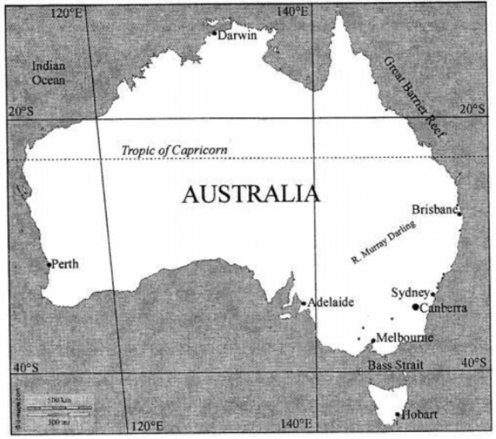
On the outline map of Australia, neatly mark and label the following :
1. the capital cities of the states
2. The narrow stretch of water that separates Tasmania from Australia
3. The longest perennial river of Australia
4. The ocean that lies west of Australia
5. A ridge-like feature made up of coral
6. write SHEEP FARMING in an appropriate place on the map where it is practised.
State and Capital
| State | Capital |
|---|---|
| Western Australia | Perth |
| Northern Territory | Darwin |
| Queensland | Brisbane |
| New South Wales | Sydney |
| Victoria | Melbourne |
| South Australia | Adelaide |
| Australian Capital Territory | Canberra |
| Tasmania | Hobart |
(ii) Bass Strait
(iii) River Murray Darling
(iv) Indian Ocean
(v) Great Barrier Reef
(vi) Western Australia, Victoria
F. Picture Study
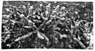
Question. This is a photograph of Australia’s Great Barrier Reef. Why do you think this reef is Australia’s biggest tourist attraction.
Answer: The reef is highly popular because its warm, crystal-clear waters support a spectacular marine ecosystem. It provides tourists with a unique opportunity to view thousands of colorful tropical fish, sea turtles, and unique crustaceans in their natural underwater habitat.
In simple words: It is a major tourist attraction because the warm, clear waters are home to a breathtaking variety of colorful tropical fish and sea creatures that are amazing to see.
Exam Tip: Link the tourism appeal to the reef's incredible biodiversity and clear, shallow waters that are ideal for snorkeling and diving.
Let's Do Something
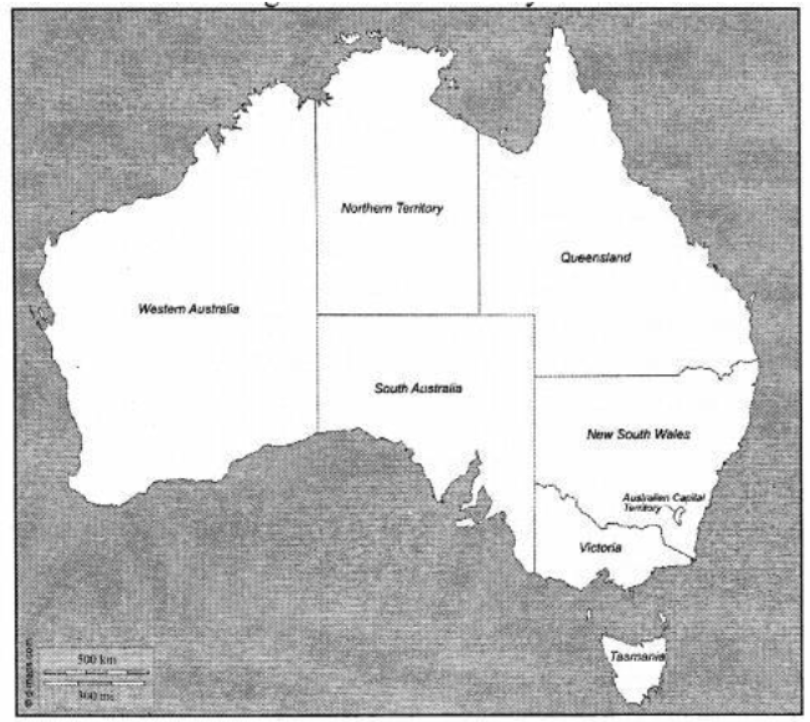
Question 1. On an outline map of Australia, mark the boundaries of South Wales-Victoria border different from the other borders ? Find out why.
Answer: While most interstate borders in Australia are straight lines drawn along meridian or latitude coordinates, the boundary between New South Wales and Victoria is uniquely irregular. This is because the majority of this border is defined by the natural course of the winding Murray River. Rather than dividing the river down the middle, the border runs along the southern high-water mark of the river, meaning the entire water body of the Murray River actually lies within the territory of New South Wales.
In simple words: Unlike other straight-line borders, the border between New South Wales and Victoria is wavy because it follows the natural path of the Murray River.
Exam Tip: Explain that natural features like rivers create winding borders, whereas astronomical/geographical coordinates create straight-line borders.
Question 2. Collect information about the Great Barrier Reef from encyclopaedias or the Internet and write a diary describing all you have learnt about it in your scrapbook.
Answer: Dear Diary,
Today, I researched the Great Barrier Reef, which is recognized as one of the seven natural wonders of our planet. It is so massive that it is larger than the Great Wall of China and stands as the only living structure on Earth visible from outer space!
Geographical Location:
This marine park stretches for over 2,300 kilometers, running almost parallel to the coast of Queensland from Bundaberg in the south to the northern tip of Cape York. It lies between 15 km and 150 km off the coast, reaching widths of up to 65 km in some sections. It is made of over 3,000 individual reef systems, sandy cays, and hundreds of tropical islands.
Incredible Marine Life:
I learned that the reef is home to an astonishing variety of life, containing more than 400 species of coral, coral sponges, mollusks, dolphins, and over 1,500 species of tropical fish. It also provides vital nesting grounds for green sea turtles and serves as a key breeding area for Antarctic humpback whales. Because of its global ecological importance, UNESCO designated the reef as a World Heritage Site in 1981.
Tourism and Activities:
Because of its exceptional natural beauty, millions of people visit the reef every year. Visitors can explore this underwater paradise through snorkeling, scuba diving, glass-bottomed boat tours, and scenic helicopter flights. It is truly one of the Earth's greatest natural treasures!
In simple words: The Great Barrier Reef is a massive natural wonder off Australia's coast that is visible from space. It is home to thousands of colorful fish, corals, sea turtles, and whales, making it a highly popular destination for diving and tourism.
Exam Tip: Presenting your research with clear subheadings (Location, Biodiversity, Significance) shows excellent organization and will score full marks.
Free study material for Geography
ICSE Voyage Solutions Class 7 Geography Chapter 16 Australia Location Area Political Physical Features
Students can now access the detailed Voyage Solutions for Chapter 16 Australia Location Area Political Physical Features on our portal. These solutions have been carefully prepared as per latest ICSE Class 7 syllabus. Each solution given above has been updated based on the current year pattern to ensure Class 7 students have the most updated Geography content.
Master Voyage Textbook Questions
Our subject experts have provided detailed explanations for all the questions found in the Voyage textbook for Class 7 Geography. We have focussed on making the concepts easy for you in Chapter 16 Australia Location Area Political Physical Features so that students can understand the concepts behind every answer. For all numerical problems and theoretical concepts these solutions will help in strengthening your analytical skill required for the ICSE examinations.
Complete Geography Exam Preparation
By using these Voyage Class 7 solutions, you can enhance your learning and identify areas that need more attention. We recommend solving the Geography Questions from the textbook first and then use our teacher-verified answers. For a proper revision of Chapter 16 Australia Location Area Political Physical Features, students should also also check our Revision Notes and Sample Papers available on studiestoday.com.
FAQs
You can download the verified Voyage solutions for Chapter 16 Australia Location Area Political Physical Features on StudiesToday.com. Our teachers have prepared answers for Class 7 Geography as per 2026-27 ICSE academic session.
Yes, our solutions for Chapter 16 Australia Location Area Political Physical Features are designed as per new 2026 ICSE standards. 40% competency-based questions required for Class 7, are included to help students understand application-based logic behind every Geography answer.
Yes, every exercise in Chapter 16 Australia Location Area Political Physical Features from the Voyage textbook has been solved step-by-step. Class 7 students will learn Geography conceots before their ICSE exams.
Yes, follow structured format of these Voyage solutions for Chapter 16 Australia Location Area Political Physical Features to get full 20% internal assessment marks and use Class 7 Geography projects and viva preparation as per ICSE 2026 guidelines.